 Filter: Categories of Wisconsin Historical Images
Filter: Community of Green Bay
Filter: Subject of rivers
Filter: Subject of roads
Filter: Categories of Wisconsin Historical Images
Filter: Community of Green Bay
Filter: Subject of rivers
Filter: Subject of roads
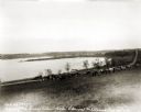
| Date: | 1927 |
|---|---|
| Description: | View down hill towards the Fox River from the Eleazer Williams home. A group of people are automobiles are near a road near the shoreline. |
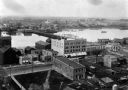
| Date: | 1889 |
|---|---|
| Description: | Elevated view of Washington Street and the Fox River and buildings nearby. |
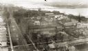
| Date: | 1889 |
|---|---|
| Description: | View of Green Bay from the top of St. Willibrord's Church. A river can be seen in the background. |

| Date: | 08 27 1825 |
|---|---|
| Description: | Map is ink on paper. Map shows plat of the town of Munnomunne, the Fox River, farm lots, and an established highway. The map is signed by "J.D. Doty, Propr... |

| Date: | 1974 |
|---|---|
| Description: | This map shows roads, highways, railroads, major arterials, towns, parks, recreational areas, and parts of Fox River and bay of Green Bay. The map includes... |

| Date: | 1868 |
|---|---|
| Description: | This map shows land ownership by name, lots, roads, railroads, and part of the Fox River. The map includes an explanation and table of witnesses to the cor... |

| Date: | 1987 |
|---|---|
| Description: | This map pictorially shows local roads, local businesses with phone numbers, and parts of Fox River and bay of Green Bay. |

| Date: | 1900 |
|---|---|
| Description: | This photostat map was probably originally created in 1835 and shows in addition to private claims, mills, roads, and trails. Green Bay and the Fox River a... |

| Date: | 04 11 1940 |
|---|---|
| Description: | This blue line print map shows survey monument markers by type and industrial buildings and covers part of the lower Fox River and East River. The map incl... |

| Date: | 1900 |
|---|---|
| Description: | This set of maps contains four sheets: "Landownership in the Vicinity of Military Reserve and Fort Howard," "Houses Along the River Road to Green Bay," "Ow... |

| Date: | 1941 |
|---|---|
| Description: | Elevated view of a highway bridge spanning the Fox River. Caption reads: "Claude Allouez Bridge at De Pere, Near Green Bay, Wis." |
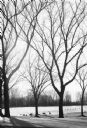
| Date: | 1979 |
|---|---|
| Description: | Geese and ducks on the shoreline and in the water, seen through trees. A paved road is in the foreground, and the far shoreline is wooded. |
If you didn't find the material you searched for, our Library Reference Staff can help.
Call our reference desk at 608-264-6535 or email us at: