 Filter: Categories of Wisconsin Historical Images
Filter: Community of Green Bay
Filter: Subject of roads
Filter: Subject of streets
Filter: Categories of Wisconsin Historical Images
Filter: Community of Green Bay
Filter: Subject of roads
Filter: Subject of streets
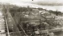
| Date: | 1889 |
|---|---|
| Description: | View of Green Bay from the top of St. Willibrord's Church. A river can be seen in the background. |

| Date: | 1974 |
|---|---|
| Description: | This map shows roads, highways, railroads, major arterials, towns, parks, recreational areas, and parts of Fox River and bay of Green Bay. The map includes... |
If you didn't find the material you searched for, our Library Reference Staff can help.
Call our reference desk at 608-264-6535 or email us at: