 Filter: Categories of Wisconsin Historical Images
Filter: Community of Green Bay
Filter: Subject of streets
Filter: Subject of bridges
Filter: Categories of Wisconsin Historical Images
Filter: Community of Green Bay
Filter: Subject of streets
Filter: Subject of bridges

| Date: | 1867 |
|---|---|
| Description: | Bird's-eye map of Green Bay and Fort Howard, Brown Co., depicts street names and street layouts, houses, trees, and the East River. A reference key at the ... |
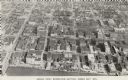
| Date: | 1956 |
|---|---|
| Description: | Caption reads: "Aerial View, Downtown Section, Green Bay, Wis." Text on reverse reads: "This aerial view shows the downtown district of the east side of ... |
| Date: | |
|---|---|
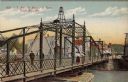
| Description: | Illustrated postcard of an iron bridge over the Fox River with pedestrians crossing. The street on the far side is lined with businesses. Caption reads: "E... |

| Date: | |
|---|---|
| Description: | Color postcard of downtown Green Bay and bridges spanning the Fox River. The Walnut Street Bridge is in the foreground. A 4-level parking garage is on the ... |
If you didn't find the material you searched for, our Library Reference Staff can help.
Call our reference desk at 608-264-6535 or email us at: