 Filter: Categories of Wisconsin Historical Images
Filter: Community of Green Bay
Filter: Subject of trees
Filter: Subject of bridges
Filter: Categories of Wisconsin Historical Images
Filter: Community of Green Bay
Filter: Subject of trees
Filter: Subject of bridges

| Date: | 1867 |
|---|---|
| Description: | Bird's-eye map of Green Bay and Fort Howard, Brown Co., depicts street names and street layouts, houses, trees, and the East River. A reference key at the ... |

| Date: | |
|---|---|
| Description: | Elevated view of the Fox River. A bridge is in the distance. |
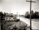
| Date: | 1920 |
|---|---|
| Description: | Elevated view of the outskirts of an unidentified town in the vicinity of Green Bay. The sign painted on the roof of the building on the left reads: "Beer ... |
| Date: | |
|---|---|
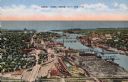
| Description: | Aerial view of Green Bay, and the Fox River headed toward the bay. Commercial and industrial buildings are on the right bank, and residential neighborhoods... |

| Date: | 1947 |
|---|---|
| Description: | Elevated view of the bridge and main building on the opposite shoreline at Pamperin Park. Caption reads: "Pamperin Park, Green Bay, Wis." |
If you didn't find the material you searched for, our Library Reference Staff can help.
Call our reference desk at 608-264-6535 or email us at: