 Filter: Categories of Wisconsin Historical Images
Filter: Community of Green Bay
Filter: Year of 1800-1899
Filter: Subject of technology
Filter: Categories of Wisconsin Historical Images
Filter: Community of Green Bay
Filter: Year of 1800-1899
Filter: Subject of technology

| Date: | 1867 |
|---|---|
| Description: | Bird's-eye map of Green Bay and Fort Howard, Brown Co., depicts street names and street layouts, houses, trees, and the East River. A reference key at the ... |
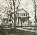
| Date: | 1860 |
|---|---|
| Description: | Exterior of the Chapman residence, at the corner of Walnut and Adams Streets. A man is standing on the sidewalk in front. |
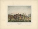
| Date: | 1842 |
|---|---|
| Description: | Menominee war dance, as depicted by Francois, Comte de Castelnau, a French naturalist and diplomat who visited Green Bay, Wisconsin about 1838. This detail... |

| Date: | 1836 |
|---|---|
| Description: | This manuscript shows the 1835 survey of the road corresponding approximately to a portion of County Trunk A in the Town of Scott, Brown County, Wisconsin.... |
If you didn't find the material you searched for, our Library Reference Staff can help.
Call our reference desk at 608-264-6535 or email us at: