 Filter: Categories of Wisconsin Historical Images
Filter: Community of Green Bay
Filter: Year of 1800-1899
Filter: Year of 1860-1869
Filter: Categories of Wisconsin Historical Images
Filter: Community of Green Bay
Filter: Year of 1800-1899
Filter: Year of 1860-1869

| Date: | 1867 |
|---|---|
| Description: | Bird's-eye map of Green Bay and Fort Howard, Brown Co., depicts street names and street layouts, houses, trees, and the East River. A reference key at the ... |
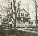
| Date: | 1860 |
|---|---|
| Description: | Exterior of the Chapman residence, at the corner of Walnut and Adams Streets. A man is standing on the sidewalk in front. |
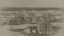
| Date: | 1865 |
|---|---|
| Description: | Elevated view of the fort, with snow on the ground. |
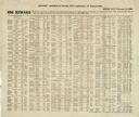
| Date: | 02 01 1864 |
|---|---|
| Description: | List of Civil War draft-dodgers issued by the Provost Marshal's office, Fifth District of Wisconsin. |

| Date: | 1868 |
|---|---|
| Description: | Map showing the northern water routes between Mississippi River and Atlantic Ocean Relief shown by hachures. Includes Profile of the Erie Canal, table of ... |

| Date: | 1868 |
|---|---|
| Description: | This map shows land ownership by name, lots, roads, railroads, and part of the Fox River. The map includes an explanation and table of witnesses to the cor... |

| Date: | 1862 |
|---|---|
| Description: | This map shows landownership on a military reserve, private claims, buildings (including Fort Howard and U.S. sawmill), swamps, public barns and fields, an... |
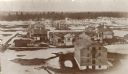
| Date: | 1867 |
|---|---|
| Description: | Elevated view of Fort Howard, from the top of a grain elevator, when it was being destroyed to make room for the Chicago and Northwestern Railway switchyar... |
If you didn't find the material you searched for, our Library Reference Staff can help.
Call our reference desk at 608-264-6535 or email us at: