 Filter: Categories of Wisconsin Historical Images
Filter: Community of Green Bay
Filter: Year of 1900-1999
Filter: Subject of land
Filter: Categories of Wisconsin Historical Images
Filter: Community of Green Bay
Filter: Year of 1900-1999
Filter: Subject of land

| Date: | 1953 |
|---|---|
| Description: | Captain John Cotton residence. Also known as "Beaupre," this Greek Revival style house was built in 1842 for Cotton, a retired U.S. Army officer. |
| Date: | 1927 |
|---|---|
| Description: | View down hill towards the Fox River from the Eleazer Williams home. A group of people are automobiles are near a road near the shoreline. |

| Date: | 1905 |
|---|---|
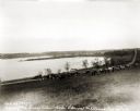
| Description: | Long Tail Lighthouse and surrounding buildings. |
| Date: | 1910 |
|---|---|
| Description: | Caption reads: "Old Light House at Long Tail Point, Green Bay, Wis." Built in 1859. A marshy area is in the foreground, and a long pier leads to the new li... |

| Date: | 1910 |
|---|---|
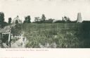
| Description: | View from road toward Mineral Springs. There is a board sidewalk in the foreground. Caption reads: "Mineral Sprints, Green Bay, Wis." |
| Date: | 1907 |
|---|---|
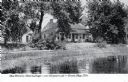
| Description: | View across water toward the Tank Cottage. Caption reads: "The Historic Tank Cottage — over 100 years old — Green Bay, Wis." |

| Date: | 08 18 1963 |
|---|---|
| Description: | Two children stand on an outdoor stairway of wood-shingle house. Caption on back of print reads, "Back steps in 'Goosetown.' a section around Broadway and ... |

| Date: | 1936 |
|---|---|
| Description: | Shoreline and wavelets near Red Banks on Lake Michigan. |

| Date: | 1900 |
|---|---|
| Description: | This map of Green Bay shows plat of the town, lots by number, local streets, the military Fort Howard, part of Fox River and part of Navarino. The map feat... |

| Date: | 1974 |
|---|---|
| Description: | This map shows roads, highways, railroads, major arterials, towns, parks, recreational areas, and parts of Fox River and bay of Green Bay. The map includes... |

| Date: | 1930 |
|---|---|
| Description: | This map shows a plat of the town, local streets, railroads, creeks, part of Fox River, and part of the bay of Green Bay. The location of the original fort... |
| Date: | 1930 |
|---|---|
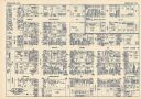
| Description: | This map shows local streets, blocks, lots, local businesses by name, and bus stops. On the back of the map is text, illustrations, and aerial views. |

| Date: | 1961 |
|---|---|
| Description: | This map shows established harbor lines, local streets, railroads, U.S. government channel, and part of Fox River. The map includes a table of reference po... |

| Date: | 1987 |
|---|---|
| Description: | This map pictorially shows local roads, local businesses with phone numbers, and parts of Fox River and bay of Green Bay. |

| Date: | 1918 |
|---|---|
| Description: | This map shows railroads, street car lines, wards, private claims, parks, railroad yards and depots, and cemeteries. The map is oriented with north to uppe... |

| Date: | 1946 |
|---|---|
| Description: | This map shows streets, wards and precincts, parks, schools, and points of interest. The map is oriented with north to the upper left. The map includes a s... |

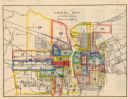
| Date: | 1950 |
|---|---|
| Description: | This map shows portions of highway remaining unchanged, proposed relocations, connecting county trunk roads existing or proposed, existing arterials, and e... |

| Date: | 1951 |
|---|---|
| Description: | This map has depths shown by bathymetric tints and soundings and relief shown by contours, the depths are shown in feet. There is an inset map of Green Bay... |
| Date: | 1956 |
|---|---|
| Description: | This map shows streets and railroads and is oriented with north to the upper left. Wards have been outlined in yellow, red, blue, and green. The back of th... |

| Date: | 1914 |
|---|---|
| Description: | This map has relief shown by hachures and shows local streets, wards, districts, railroads, Fox River, and part of Bay of Green Bay. Wards are shown in dar... |
If you didn't find the material you searched for, our Library Reference Staff can help.
Call our reference desk at 608-264-6535 or email us at: