Filter: Categories of Wisconsin Historical Images
Filter: Community of Green Bay
Filter: Year of 1900-1999
Filter: Subject of roads
Filter: Categories of Wisconsin Historical Images
Filter: Community of Green Bay
Filter: Year of 1900-1999
Filter: Subject of roads
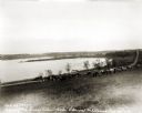
| Date: | 1927 |
|---|---|
| Description: | View down hill towards the Fox River from the Eleazer Williams home. A group of people are automobiles are near a road near the shoreline. |
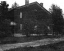
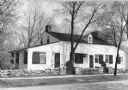
| Date: | 1900 |
|---|---|
| Description: | David Grignon's house, built by Judge Lawe in 1832, burned 1903. |
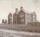
| Date: | 1905 |
|---|---|
| Description: | Front view across unpaved road towards a high school, with a bicycle against a tall pole, and a fence in the foreground. |

| Date: | 1920 |
|---|---|
| Description: | "Miss Mahan's School" with a tree in front and a farmhouse next door. |

| Date: | 1910 |
|---|---|
| Description: | View from road toward Mineral Springs. There is a board sidewalk in the foreground. Caption reads: "Mineral Sprints, Green Bay, Wis." |

| Date: | 1910 |
|---|---|
| Description: | View across field toward the hospital. Caption reads: "St. Vincent Hospital, Green Bay, Wis." |
| Date: | 1955 |
|---|---|
| Description: | View of Tank Cottage. The cottage was built in 1776 by Joseph Roi, a fur trader, who lived in it until 1805 when it was purchased by Jacques Porlier. Later... |
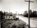
| Date: | 1920 |
|---|---|
| Description: | Elevated view of the outskirts of an unidentified town in the vicinity of Green Bay. The sign painted on the roof of the building on the left reads: "Beer ... |
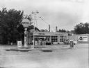
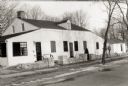
| Date: | 09 09 1959 |
|---|---|
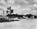
| Description: | Service Station offering "Shellubrication." |
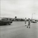
| Date: | 1973 |
|---|---|
| Description: | Green Bay Packers quarterback Scott Hunter (#16) dodging traffic on his way to the practice field. A large group of fans wait along the fence on the other ... |
| Date: | 06 08 1959 |
|---|---|
| Description: | Exterior view of Noel's Bait and Sport Shop with cars parked in the lot in front of the building. Fishing nets can be seen on display in the window. The bu... |
| Date: | 09 25 1957 |
|---|---|
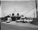
| Description: | Exterior view from road of Sneezer's Snack Shop with two cars in the parking lot. The neon sign features a chef holding a hamburger on a plate. |

| Date: | 1974 |
|---|---|
| Description: | This map shows roads, highways, railroads, major arterials, towns, parks, recreational areas, and parts of Fox River and bay of Green Bay. The map includes... |

| Date: | 1987 |
|---|---|
| Description: | This map pictorially shows local roads, local businesses with phone numbers, and parts of Fox River and bay of Green Bay. |

| Date: | 1950 |
|---|---|
| Description: | This map shows portions of highway remaining unchanged, proposed relocations, connecting county trunk roads existing or proposed, existing arterials, and e... |

| Date: | 1900 |
|---|---|
| Description: | This photostat map shows private claim owners, natural meadows, roads, saw and grist mills, and Fort Howard. The upper right corner includes annotations an... |

| Date: | 1900 |
|---|---|
| Description: | This photostat map was probably originally created in 1835 and shows in addition to private claims, mills, roads, and trails. Green Bay and the Fox River a... |

| Date: | 04 11 1940 |
|---|---|
| Description: | This blue line print map shows survey monument markers by type and industrial buildings and covers part of the lower Fox River and East River. The map incl... |
If you didn't find the material you searched for, our Library Reference Staff can help.
Call our reference desk at 608-264-6535 or email us at: