 Filter: Categories of Wisconsin Historical Images
Filter: Community of Janesville
Filter: Subject of human settlements
Filter: Categories of Wisconsin Historical Images
Filter: Community of Janesville
Filter: Subject of human settlements

| Date: | 05 1981 |
|---|---|
| Description: | Former Harrison OK Used Car lot, Center Avenue (US Highway 51). |

| Date: | 05 1981 |
|---|---|
| Description: | Industrial building, located at North Main Street at Pease Court. |
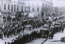
| Date: | 1925 |
|---|---|
| Description: | Elevated view of Union veterans, some holding a banner reading "Iron Brigade," marching on a downtown street in a parade during a state encampment. |
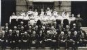
| Date: | 1908 |
|---|---|
| Description: | Group portrait of men and women at a Civil War reunion posed on the steps in front of a building. Those identified are 4) C. W. Sackett of Beloit 5) Herman... |
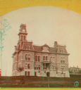
| Date: | 1890 |
|---|---|
| Description: | Stereograph of the Rock County Court House. |
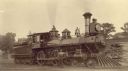
| Date: | 1886 |
|---|---|
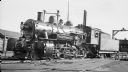
| Description: | Right side view of Chicago, Milwaukee & St. Paul Railway locomotive engine no. 632. |
| Date: | 1937 |
|---|---|
| Description: | Left side view of the locomotive engine no. 2872, a steam locomotive of the Chicago, Milwaukee, St. Paul and Pacific Railroad Company. |
| Date: | |
|---|---|
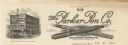
| Description: | Letterhead of the Parker Pen Company, with a three-quarter view of the company building, with people walking on the sidewalk, and a streetcar, automobiles,... |

| Date: | |
|---|---|
| Description: | An ink and water color on paper, hand-drawn map showing the section divisions in the southern half of the Janesville Township (Township 3 North, Range 12 E... |
| Date: | 1903 |
|---|---|
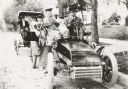
| Description: | George S. Parker and family seated in their car, one of the first automobiles in Janesville. Behind them is a couple in another car. |

| Date: | 1860 |
|---|---|
| Description: | Map showing a plat of the city, land ownership by name, wards by number, local streets, buildings, fair grounds, nurseries, and part of Rock River. The map... |
| Date: | 1927 |
|---|---|
| Description: | This map shows a plat of city, a numbering system, local streets, railroads, and part of the Rock River. The map is indexed by street name and reads: "Copy... |

| Date: | 1873 |
|---|---|
| Description: | This map shows landownership and acreages, lot and block numbers, roads and railroads, marshes, schools, churches, mills, rural buildings, and quarries. Re... |

| Date: | 1955 |
|---|---|
| Description: | This map includes a street index and shows municipal golf course, parks, schools, cemeteries, Janesville County Club, and industrial sites. The back of the... |

| Date: | 1900 |
|---|---|
| Description: | This map includes an index of streets and schools, and shows parks and public lands, as well as industrial sites. |

| Date: | 1973 |
|---|---|
| Description: | This map includes an index of streets and schools and also shows parks, schools and public lands, and industrial sites. Portions of the map are in green an... |

| Date: | 1900 |
|---|---|
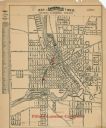
| Description: | This map is indexed and shows numbering system, public buildings and parks, wards, and voting booths. |
| Date: | |
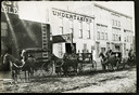
|---|---|
| Description: | View from across unpaved street of four men with horse-drawn hearses lined up in front of an undertaking building. The other storefronts are a stable on th... |
| Date: | 1924 |
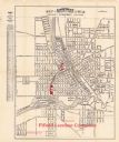
|---|---|
| Description: | This map of Janesville was distrusted by the Fifield Lumber Company and features labeled streets, the Rock River, and Fifield Lumber Company buildings in r... |
| Date: | |
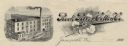
|---|---|
| Description: | Memohead of the Rock River Cotton Company, with an elevated three-quarter view of the company building on the left, and a branch of the cotton plant with b... |
If you didn't find the material you searched for, our Library Reference Staff can help.
Call our reference desk at 608-264-6535 or email us at: