 Filter: Categories of Wisconsin Historical Images
Filter: Community of Kewaunee
Filter: Type of Map or Atlas
Filter: Categories of Wisconsin Historical Images
Filter: Community of Kewaunee
Filter: Type of Map or Atlas
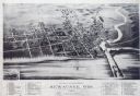
| Date: | 1893 |
|---|---|
| Description: | Bird's-eye map of Kewaunee, with inset of The Kewaunee and Frankfort Car Ferry Line. |

| Date: | 1840 |
|---|---|
| Description: | This map of Kewaunee shows lot and block numbers, Lake Michigan, and includes a location map showing proposed railroads. The map includes manuscript annota... |

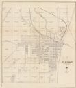
| Date: | 1961 |
|---|---|
| Description: | This map shows streets and some points of interest. Kewaunee River and Lake Michigan are both labeled. |
| Date: | 1930 |
|---|---|
| Description: | This cadastral map shows ownership and acreage of lots. Streets, the Kewaunee River, and Lake Michigan are labeled. |

| Date: | 1926 |
|---|---|
| Description: | This blueprint manuscript map shows buildings, railroads, and United States property. Water depths shown by soundings, tints, and isolines. |

| Date: | 1937 |
|---|---|
| Description: | This is map 3 from a set of 4 taken from an atlas. The map shows streets, neighborhoods, lots, and railroad tracks. Lake Michigan, the Kewaunee River, and ... |
| Date: | 1900 |
|---|---|
| Description: | This photocopy map shows land parcels, block numbers, streets, the Kewaunee River, and Lake Michigan on the far right side. The original map was created ar... |
If you didn't find the material you searched for, our Library Reference Staff can help.
Call our reference desk at 608-264-6535 or email us at:
