 Filter: Categories of Wisconsin Historical Images
Filter: Community of Kewaunee
Filter: Categories of Wisconsin Historical Images
Filter: Community of Kewaunee
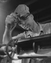
| Date: | 07 20 1958 |
|---|---|
| Description: | Close-up of a man checking part of a metal lathe with a caliper. |
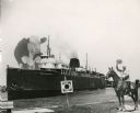
| Date: | |
|---|---|
| Description: | Composite photograph in the "Tall Tale" style. An enormous bovine stands on the front deck of the Pere Marquette 21, a steamer. On the right, on the... |
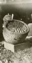
| Date: | 1932 |
|---|---|
| Description: | Bee skep turned over to show bees and combs inside. |
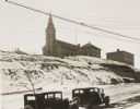
| Date: | 1934 |
|---|---|
| Description: | Terracing on Ellis Street during the winter. Two automobiles are parked alongside the road in the foreground. The terraced hill is snow covered, and a chur... |
| Date: | 1935 |
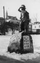
|---|---|
| Description: | Pioneer Monument in memory of Chief Simon Kahquados, Jacques Vieau, John Volk, James Duane Doty, Joshua Hathaway, Henry S. Baird, Co. Starkweather, Frank D... |
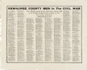
| Date: | |
|---|---|
| Description: | A poster with a list of names of Civil War soldiers arranged by military unit. |
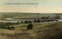
| Date: | 1909 |
|---|---|
| Description: | Caption reads: "Ox Bow on the Kewaunee River near Kewaunee, Wis." |
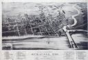
| Date: | 1893 |
|---|---|
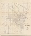
| Description: | Bird's-eye map of Kewaunee, with inset of The Kewaunee and Frankfort Car Ferry Line. |
| Date: | 2008 |
|---|---|
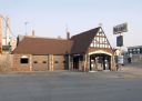
| Description: | This Tudor Revival-style Wadhams Service Station at 302 Ellis Street opened in 1931. The Kewaunee Enterprise proclaimed it a "very fine improvement in the ... |
| Date: | 2008 |
|---|---|
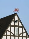
| Description: | A red and winged horse weather vane sits atop the Mobil station. |
| Date: | 02 18 1958 |
|---|---|
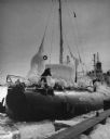
| Description: | The SS Meteor, a Great Lakes cargo steamship of whaleback design, coming into harbor. The ship is covered with snow and ice and the surface of the l... |

| Date: | 1926 |
|---|---|
| Description: | This blueprint manuscript map shows buildings, railroads, and United States property. Water depths shown by soundings, tints, and isolines. |
| Date: | 1930 |
|---|---|
| Description: | This cadastral map shows ownership and acreage of lots. Streets, the Kewaunee River, and Lake Michigan are labeled. |
| Date: | 1955 |
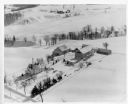
|---|---|
| Description: | Aerial view of a farm in winter, with the farmhouse, barn, and outbuildings blanketed in snow. The name Cedar Spring Farm is on the barn. Another farm is i... |

| Date: | 1937 |
|---|---|
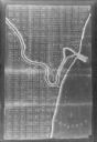
| Description: | This is map 3 from a set of 4 taken from an atlas. The map shows streets, neighborhoods, lots, and railroad tracks. Lake Michigan, the Kewaunee River, and ... |
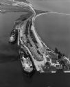
| Date: | 09 17 1948 |
|---|---|
| Description: | Aerial view of two Lake Michigan ferries tied up at harbor slips. The eastern terminus of the Green Bay Route was the Lake Michigan port city of Kewaunee. ... |
| Date: | 1915 |
|---|---|
| Description: | View of the interior of a bank, with a row of teller cages on the left, and columns on the right. The president's office is on the far left. Caption reads:... |
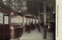
| Date: | 09 15 1960 |
|---|---|
| Description: | View across water towards a carferry named "City of Flint," moored at a dock. There are buildings on the dock on the right. |
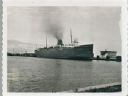
| Date: | 1900 |
|---|---|
| Description: | This photocopy map shows land parcels, block numbers, streets, the Kewaunee River, and Lake Michigan on the far right side. The original map was created ar... |
If you didn't find the material you searched for, our Library Reference Staff can help.
Call our reference desk at 608-264-6535 or email us at:
