 Filter: Categories of Wisconsin Historical Images
Filter: Community of Louisville
Filter: Subject of cities and towns
Filter: Categories of Wisconsin Historical Images
Filter: Community of Louisville
Filter: Subject of cities and towns
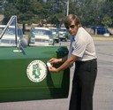
| Date: | 1975 |
|---|---|
| Description: | Color photograph of an air pollution inspector wearing sunglasses is holding his badge near the door emblem on his International Scout II pickup. The truck... |
| Date: | 1973 |
|---|---|
| Description: | Group standing in front of the SCEF (Southern Conference Education Fund) headquarters. The group includes Anne Braden in the blue jacket, and Carl Braden ... |
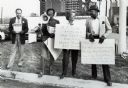
| Date: | |
|---|---|
| Description: | Strike of the United Food and Commercial Workers Union (UFCW) Local 227 against a Winn-Dixie grocery store. Identified among the picketers are Rev. Charles... |

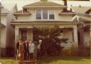
| Date: | 05 16 1954 |
|---|---|
| Description: | Andrew Wade and his wife and daughter stand in front of their house. Their front windows have been damaged by rocks and rifle shots. |
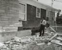
| Date: | 06 27 1954 |
|---|---|
| Description: | Police officer inspecting the damage to the home of Andrew Wade and his family after it was bombed. |

| Date: | 05 29 1894 |
|---|---|
| Description: | A crowd of people gathered on a wharf with boats in the foreground. |
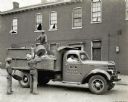
| Date: | 05 17 1938 |
|---|---|
| Description: | Three men load garbage onto the back of an International DS-35 truck owned by the City of Louisville, while two men sit in the truck's cab. The truck is on... |

| Date: | 1915 |
|---|---|
| Description: | Two drivers for "Southern Star Products" out of Louisville Provision Company pose next to International model F, or 31 trucks. The trucks are parked outsid... |

| Date: | 1925 |
|---|---|
| Description: | Exterior view of the International Harvester Company Louisville branch. Several automobiles are parked along the street in front of the building. On the fa... |

| Date: | 1949 |
|---|---|
| Description: | Aerial view of factory buildings and grounds at International Harvester's Louisville Works. Roads, fields and trees surround the factory. In the foreground... |

| Date: | 1831 |
|---|---|
| Description: | Map of the city of Louisville, Kentucky on the Ohio River showing streets and numbered lots. The Ohio River, Corn Island, and the Louisville and Portland C... |

| Date: | 1828 |
|---|---|
| Description: | Map of the Louisville and Portland Canal on the Ohio River. The map shows Louisville, Shippingsport, Clarksville, Jeffersonville, Gravel Island, Corn Islan... |

| Date: | 1793 |
|---|---|
| Description: | Detailed topographical map of the Ohio River between Clarkville and Louisville. It shows plots of farmland, forest, islands, garden plots, houses, Fort Fe... |

| Date: | 1960 |
|---|---|
| Description: | Aerial View of Louisville Engine & Tractor Works. |
If you didn't find the material you searched for, our Library Reference Staff can help.
Call our reference desk at 608-264-6535 or email us at: