 Filter: Categories of Wisconsin Historical Images
Filter: Community of Menasha
Filter: Creator Name of Unknown
Filter: Subject of lakes
Filter: Categories of Wisconsin Historical Images
Filter: Community of Menasha
Filter: Creator Name of Unknown
Filter: Subject of lakes

| Date: | 1870 |
|---|---|
| Description: | Elevated view of City Square, where the Bank of Menasha is seen on the corner and Little Lake Butte des Mortes is in the distance. |
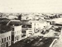
| Date: | 1870 |
|---|---|
| Description: | Elevated view of Main Street looking east toward the Fox River and the boat landing. Lake Winnebago is in the distance. |

| Date: | 07 21 1835 |
|---|---|
| Description: | This map is ink and watercolor on tracing paper and shows township lines surveyed by Mullett and Brink, subdivision lines surveyed by A.G. Ellis, and part ... |
If you didn't find the material you searched for, our Library Reference Staff can help.
Call our reference desk at 608-264-6535 or email us at: