 Filter: Categories of Wisconsin Historical Images
Filter: Community of Menasha
Filter: Subject of land
Filter: Categories of Wisconsin Historical Images
Filter: Community of Menasha
Filter: Subject of land
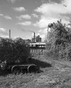
| Date: | 09 29 1963 |
|---|---|
| Description: | The Menasha Woodenware plant and water tower on Doty Island from across the Fox River canal, with a small railroad dolly in the foreground. |
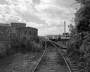
| Date: | 09 29 1963 |
|---|---|
| Description: | View down railroad tracks towards the railroad bridge, with industrial plants on Doty Island. |
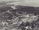
| Date: | 1955 |
|---|---|
| Description: | Aerial view of "the island" with the Marathon Corporation paper mills. The Fox River flowing out of Lake Winnebago separates the two cities, Neenah and Men... |
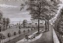
| Date: | |
|---|---|
| Description: | A drawing from Harney's "History of Winnebago County" of E.L. Mathewson's home on Doty Island. |

| Date: | 1712 |
|---|---|
| Description: | This drawing, based on an 1897 survey, appeared in the 1899 Proceedings of the State Historical Society of Wisconsin, accompanying Publius V. Lawson's arti... |

| Date: | 1881 |
|---|---|
| Description: | Ink, watercolor, and pencil on paper. Top of the map reads: "NORTHERN OUTLET MENASHA MEANDER LINES Scale 132ft 1 INCH Var S.E. Survey Completed Spet. 23 18... |

| Date: | 1872 |
|---|---|
| Description: | Shows landowners, buildings, lot numbers, roads and railroads. Includes Menasha business directory. |

| Date: | 08 24 1899 |
|---|---|
| Description: | Pen-and-ink and color on paper. Also shows probable routes of the French explorers Constant le Marchand de Lignery in 1728 and Louis de la Porte de Louvign... |

| Date: | 1881 |
|---|---|
| Description: | This map is pen and ink on paper and shows part of the city of Menasha, local streets, Dendo Island, part of Lake Winnebago, and part of Little Lake Butte ... |

| Date: | 07 21 1835 |
|---|---|
| Description: | This map is ink and watercolor on tracing paper and shows township lines surveyed by Mullett and Brink, subdivision lines surveyed by A.G. Ellis, and part ... |

| Date: | 12 1886 |
|---|---|
| Description: | This map is ink and pen on tracing cloth and shows land ownership by name, canals, local streets, section lines, and original low water lines in blue. The ... |

| Date: | 1931 |
|---|---|
| Description: | This map shows heavy industrial districts (yellow), commercial and light manufacturing districts (red), and residential districts (white) as well as a plat... |
If you didn't find the material you searched for, our Library Reference Staff can help.
Call our reference desk at 608-264-6535 or email us at: