 Filter: Categories of Wisconsin Historical Images
Filter: Community of Menasha
Filter: Subject of streets
Filter: Subject of human settlements
Filter: Categories of Wisconsin Historical Images
Filter: Community of Menasha
Filter: Subject of streets
Filter: Subject of human settlements
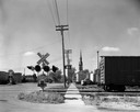
| Date: | 06 16 1963 |
|---|---|
| Description: | View down street towards the Menasha railroad crossing and a Roman Catholic Church. |

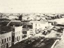
| Date: | 1870 |
|---|---|
| Description: | Elevated view of City Square, where the Bank of Menasha is seen on the corner and Little Lake Butte des Mortes is in the distance. |
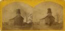
| Date: | 1871 |
|---|---|
| Description: | Stereograph of the Congregational Church on the corner of Broad and Milwaukee Streets. |
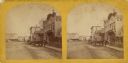
| Date: | 1871 |
|---|---|
| Description: | Stereograph of the town square and Main Street. The three-story building in the center was operated as the National Hotel. It was later burned down and was... |
| Date: | 1870 |
|---|---|
| Description: | Elevated view of Main Street looking east toward the Fox River and the boat landing. Lake Winnebago is in the distance. |

| Date: | 1870 |
|---|---|
| Description: | The corner of unpaved Main Street and Tayco Street looking south towards Doty Island. The slanting timbers controlled the primitive draw bridge across the ... |

| Date: | 1870 |
|---|---|
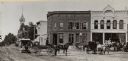
| Description: | The National Hotel on town square off of Main Street. A group of people and horse-drawn vehicles are in front of the hotel. |
| Date: | |
|---|---|
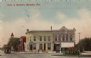
| Description: | Looking west on to Public Square. There are horse-drawn vehicles and a streetcar in the foreground. |

| Date: | 1856 |
|---|---|
| Description: | ". . . The upper Grand Chute was the last of the 'improvements' paintings signed by Brookes and Stevenson. Yet there were two more vital links in the Fox R... |

| Date: | 1881 |
|---|---|
| Description: | Ink, watercolor, and pencil on paper. Top of the map reads: "NORTHERN OUTLET MENASHA MEANDER LINES Scale 132ft 1 INCH Var S.E. Survey Completed Spet. 23 18... |

| Date: | 1872 |
|---|---|
| Description: | Shows landowners, buildings, lot numbers, roads and railroads. Includes Menasha business directory. |

| Date: | 1920 |
|---|---|
| Description: | Shows lot and block numbers. Includes manuscript annotations showing original Wisconsin Central Railway line in red which reads: "Original W.C. Line in Men... |

| Date: | 1881 |
|---|---|
| Description: | This map is pen and ink on paper and shows part of the city of Menasha, local streets, Dendo Island, part of Lake Winnebago, and part of Little Lake Butte ... |

| Date: | 07 21 1835 |
|---|---|
| Description: | This map is ink and watercolor on tracing paper and shows township lines surveyed by Mullett and Brink, subdivision lines surveyed by A.G. Ellis, and part ... |

| Date: | 12 1886 |
|---|---|
| Description: | This map is ink and pen on tracing cloth and shows land ownership by name, canals, local streets, section lines, and original low water lines in blue. The ... |

| Date: | 1974 |
|---|---|
| Description: | This map shows streets, Lake Winnebago, Little Lake Butte Des Morts, and the Fox River. Also included is text on the Fox River Waterways and the history of... |

| Date: | 1945 |
|---|---|
| Description: | This map shows block and lot numbers, subdivisions, streets, railroads, and abandoned right of ways. Some areas are shown in yellow and pink. The city seal... |

| Date: | 1931 |
|---|---|
| Description: | This map shows heavy industrial districts (yellow), commercial and light manufacturing districts (red), and residential districts (white) as well as a plat... |
| Date: | |
|---|---|
| Description: | Exterior view of the Hotel Menasha. There is a car and driver at the curb. Caption reads: "Hotel Menasha, Menasha, Wis." |
| Date: | |
|---|---|
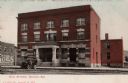
| Description: | View from street towards a corner bank and surrounding buildings. A streetcar is coming up the street. Caption reads: "Bank of Menasha, Menasha, Wis." |
If you didn't find the material you searched for, our Library Reference Staff can help.
Call our reference desk at 608-264-6535 or email us at: