 Filter: Categories of Wisconsin Historical Images
Filter: Community of Menasha
Filter: Subject of transportation
Filter: Categories of Wisconsin Historical Images
Filter: Community of Menasha
Filter: Subject of transportation
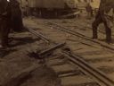
| Date: | 08 24 1888 |
|---|---|
| Description: | The George A. Whiting Paper Mill after a fire on August 24, 1888. Men and women are standing near the damaged railroad tracks. Sixteen men were killed by t... |
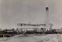
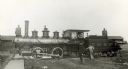
| Date: | 1885 |
|---|---|
| Description: | The George A. Whiting Paper Mills with men posing on switcher engines in front of the buildings. The engines are, (left to right): Chicago and Northwestern... |
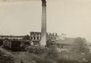
| Date: | 08 24 1888 |
|---|---|
| Description: | Slightly elevated view of the George A. Whiting Paper Mill after a fire on August 24, 1888. Sixteen men were killed by the explosion of a bleacher; the ble... |

| Date: | 1910 |
|---|---|
| Description: | The Fox River in Menasha showing the mill area. Caption reads: "River View, Menasha, Wis." |

| Date: | |
|---|---|
| Description: | Exterior view from road of the Elisha D. Smith Library. The library opened in 1898 funded with a gift of $20,000 from E.D. Smith. Over the main entrance, a... |
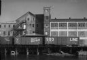
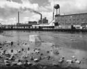
| Date: | 09 29 1963 |
|---|---|
| Description: | View of Gilbert Paper Company from a railroad bridge on the Fox River. Three rail cars are stopped in front of the factory. |

| Date: | 09 29 1963 |
|---|---|
| Description: | View across water of a railroad bridge along the side of a strip of industrial buildings. Railroad cars are stopped in front of the buildings. |
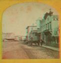
| Date: | 1871 |
|---|---|
| Description: | A stereograph of the town square and Main Street. The three-story building visible in the center of the photograph was operated as the National Hotel. It w... |
| Date: | |
|---|---|
| Description: | Left side view of Chicago,Milwaukee & St. Paul Railway locomotive engine no. 901, class J2, built by Borrks Locomotive Works in 1887. Engineer Jake Rhyner ... |

| Date: | 1856 |
|---|---|
| Description: | ". . . The upper Grand Chute was the last of the 'improvements' paintings signed by Brookes and Stevenson. Yet there were two more vital links in the Fox R... |

| Date: | 1881 |
|---|---|
| Description: | Ink, watercolor, and pencil on paper. Top of the map reads: "NORTHERN OUTLET MENASHA MEANDER LINES Scale 132ft 1 INCH Var S.E. Survey Completed Spet. 23 18... |

| Date: | 1872 |
|---|---|
| Description: | Shows landowners, buildings, lot numbers, roads and railroads. Includes Menasha business directory. |

| Date: | 08 24 1899 |
|---|---|
| Description: | Pen-and-ink and color on paper. Also shows probable routes of the French explorers Constant le Marchand de Lignery in 1728 and Louis de la Porte de Louvign... |

| Date: | 1920 |
|---|---|
| Description: | Shows lot and block numbers. Includes manuscript annotations showing original Wisconsin Central Railway line in red which reads: "Original W.C. Line in Men... |

| Date: | 1881 |
|---|---|
| Description: | This map is pen and ink on paper and shows part of the city of Menasha, local streets, Dendo Island, part of Lake Winnebago, and part of Little Lake Butte ... |

| Date: | 07 21 1835 |
|---|---|
| Description: | This map is ink and watercolor on tracing paper and shows township lines surveyed by Mullett and Brink, subdivision lines surveyed by A.G. Ellis, and part ... |

| Date: | 12 1886 |
|---|---|
| Description: | This map is ink and pen on tracing cloth and shows land ownership by name, canals, local streets, section lines, and original low water lines in blue. The ... |

| Date: | 1974 |
|---|---|
| Description: | This map shows streets, Lake Winnebago, Little Lake Butte Des Morts, and the Fox River. Also included is text on the Fox River Waterways and the history of... |
| Date: | 1963 |
|---|---|
| Description: | A diagonal view down the canal of the Menasha Woodenware Company. Along the opposite side of the canal are boxcars on an elevated railroad track over the w... |

| Date: | 1945 |
|---|---|
| Description: | This map shows block and lot numbers, subdivisions, streets, railroads, and abandoned right of ways. Some areas are shown in yellow and pink. The city seal... |
If you didn't find the material you searched for, our Library Reference Staff can help.
Call our reference desk at 608-264-6535 or email us at: