 Filter: Categories of Wisconsin Historical Images
Filter: Community of Menasha
Filter: Year of 1800-1899
Filter: Categories of Wisconsin Historical Images
Filter: Community of Menasha
Filter: Year of 1800-1899
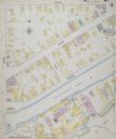
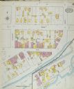
| Date: | 1887 |
|---|---|
| Description: | Sanborn-Perris fire insurance maps for city of Menasha. |
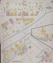
| Date: | 1887 |
|---|---|
| Description: | Sanborn-Perris fire insurance maps for city of Menasha. |
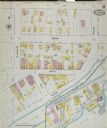
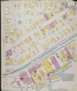
| Date: | 1891 |
|---|---|
| Description: | Sanborn-Perris fire insurance maps for city of Menasha. |
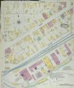
| Date: | 1891 |
|---|---|
| Description: | Sanborn-Perris fire insurance maps for city of Menasha. |
| Date: | 1895 |
|---|---|
| Description: | Sanborn-Perris fire insurance maps for city of Menasha. |
| Date: | 1895 |
|---|---|
| Description: | Sanborn-Perris fire insurance maps for city of Menasha. |
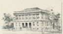
| Date: | 1899 |
|---|---|
| Description: | Copy of an artist's rendition of an exterior view of the Elisha D. Smith Library. Pen and ink drawing is signed: "G.J. de Gelleke, 1899." Bottom of drawing... |
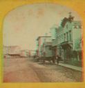
| Date: | 1871 |
|---|---|
| Description: | A stereograph of the town square and Main Street. The three-story building visible in the center of the photograph was operated as the National Hotel. It w... |

| Date: | 1856 |
|---|---|
| Description: | ". . . The upper Grand Chute was the last of the 'improvements' paintings signed by Brookes and Stevenson. Yet there were two more vital links in the Fox R... |

| Date: | 1881 |
|---|---|
| Description: | Ink, watercolor, and pencil on paper. Top of the map reads: "NORTHERN OUTLET MENASHA MEANDER LINES Scale 132ft 1 INCH Var S.E. Survey Completed Spet. 23 18... |

| Date: | 1872 |
|---|---|
| Description: | Shows landowners, buildings, lot numbers, roads and railroads. Includes Menasha business directory. |

| Date: | 08 24 1899 |
|---|---|
| Description: | Pen-and-ink and color on paper. Also shows probable routes of the French explorers Constant le Marchand de Lignery in 1728 and Louis de la Porte de Louvign... |

| Date: | 1881 |
|---|---|
| Description: | This map is pen and ink on paper and shows part of the city of Menasha, local streets, Dendo Island, part of Lake Winnebago, and part of Little Lake Butte ... |

| Date: | 07 21 1835 |
|---|---|
| Description: | This map is ink and watercolor on tracing paper and shows township lines surveyed by Mullett and Brink, subdivision lines surveyed by A.G. Ellis, and part ... |

| Date: | 12 1886 |
|---|---|
| Description: | This map is ink and pen on tracing cloth and shows land ownership by name, canals, local streets, section lines, and original low water lines in blue. The ... |

| Date: | 1886 |
|---|---|
| Description: | View across water towards the George Whiting Paper Mill on the Lawson Canal. |
If you didn't find the material you searched for, our Library Reference Staff can help.
Call our reference desk at 608-264-6535 or email us at: