 Filter: Categories of Wisconsin Historical Images
Filter: Community of Sheboygan
Filter: Creator Name of Sheboygan City Engineer
Filter: Categories of Wisconsin Historical Images
Filter: Community of Sheboygan
Filter: Creator Name of Sheboygan City Engineer

| Date: | 1914 |
|---|---|
| Description: | This map shows Sheboygan in 1914. The top of the map has the date of "NOV 17 1916" stamped in red ink. The map shows numbered plots and labeled streets, an... |
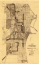
| Date: | 1935 |
|---|---|
| Description: | This map created by the Sheboygan City Engineer department shows five different types of land use in the city in 1935. A legend in the bottom right corner ... |

| Date: | 1956 |
|---|---|
| Description: | This maps shows voting precincts and polling places as well as wards. Streets and the Sheboygan River are labeled. The bottom right of the map features a l... |
If you didn't find the material you searched for, our Library Reference Staff can help.
Call our reference desk at 608-264-6535 or email us at: