 Filter: Categories of Wisconsin Historical Images
Filter: Community of Sturgeon Bay
Filter: Subject of boats and boating
Filter: Categories of Wisconsin Historical Images
Filter: Community of Sturgeon Bay
Filter: Subject of boats and boating
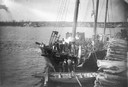
| Date: | 1888 |
|---|---|
| Description: | Elevated view of men repairing a docked, damaged ship. A shoreline is in the distance. |

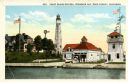
| Date: | 1953 |
|---|---|
| Description: | View across water towards the Sturgeon Bay Canal Lighthouse, with a group of people in a motorboat in the foreground. |
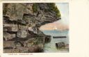
| Date: | 1910 |
|---|---|
| Description: | View of Lover's Leap, with a group of people posing on the rocks and sailboats in the background. Caption reads: "Lover's Leap, Sturgeon Bay, Wis." |
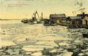
| Date: | 1910 |
|---|---|
| Description: | A springtime harbor scene from Sturgeon Bay. Chunks of ice are floating on the surface of the water. Caption reads: "Harbor scene at springtime. Sturgeon B... |
| Date: | 1900 |
|---|---|
| Description: | View of the coast guard station from the water with multiple sailors lined up near the shore. Caption reads: "Coast Guard Station, Sturgeon Bay, Door Count... |
| Date: | 1900 |
|---|---|
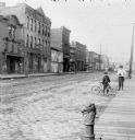
| Description: | Syl stands holding an umbrella near an unidentified boy who is leaning on a bicycle on the edge of a cobblestone street. Storefronts are along the street o... |

| Date: | 1906 |
|---|---|
| Description: | Hand-colored postcard view of the Sturgeon Bay ship canal from the bay toward shore. A sailboat is on the left and a lighthouse is on shore on the right. C... |

| Date: | 1895 |
|---|---|
| Description: | Seven men, standing informally, some wearing “yachting caps”, on a dock, presumably in Sturgeon Bay, Wis. |
| Date: | 1958 |
|---|---|
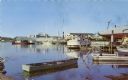
| Description: | View from pier of Peterson's Boat Works in Sturgeon Bay. |

| Date: | 06 25 1901 |
|---|---|
| Description: | This map shows beacons, buoys, docks, quarries, streets, and buildings. The map inset shows the Harbor of refuge at entrance to Sturgeon Bay and Lake Michi... |

| Date: | 12 28 1908 |
|---|---|
| Description: | This map shows beacons, buildings, streets, and quarries. Two inset maps include: Vicinity of Sturgeon Bay, Wis. and the Harbor of refuge at entrance to St... |
| Date: | 01 06 1958 |
|---|---|
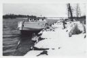
| Description: | View from snowy shoreline of Mooring Basin at bay end of Ship Canal. The boat moored in the foreground is named "Allie." It is tethered to a post on the sh... |
| Date: | 01 06 1958 |
|---|---|
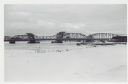
| Description: | View from snowy shoreline of Highway Bridge, the east approach. The lake is frozen. Just beyond the shoreline a boat is moored at a landing, and an automob... |

| Date: | |
|---|---|
| Description: | Aerial view of harbors and bridge. Farm fields are on either side of the bridge. The city of Sturgeon Bay is in the distance. There are docks along the sho... |

| Date: | 05 1973 |
|---|---|
| Description: | Steve Hopkins and Roger Debenham posing in Sturgeon Bay with seven trout they caught on Lake Michigan hanging from pegs under a sign that reads, "Bay Chart... |

| Date: | |
|---|---|
| Description: | Steve Hopkins and two men standing on a Bay Charter Service boat docked at the Baudhuin Yacht Harbor marina in Sturgeon Bay. The yacht club house stands be... |
If you didn't find the material you searched for, our Library Reference Staff can help.
Call our reference desk at 608-264-6535 or email us at: