 Filter: Categories of Wisconsin Historical Images
Filter: Community of Sturgeon Bay
Filter: Subject of land
Filter: Categories of Wisconsin Historical Images
Filter: Community of Sturgeon Bay
Filter: Subject of land
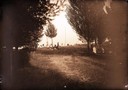
| Date: | 1890 |
|---|---|
| Description: | People in a cemetery. Includes a view of the Scofield family monument. |
| Date: | 1915 |
|---|---|
| Description: | Colorized view of the Sherwood Point Lighthouse. Caption reads: "Sherwood Point Light House, Sturgeon Bay, Wis." |
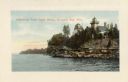
| Date: | 1910 |
|---|---|
| Description: | View of Sawyer Harbor as seen from Government Bluff. |
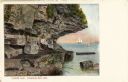
| Date: | 1910 |
|---|---|
| Description: | View of Lover's Leap, with a group of people posing on the rocks and sailboats in the background. Caption reads: "Lover's Leap, Sturgeon Bay, Wis." |
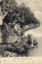
| Date: | 1906 |
|---|---|
| Description: | View of Lover's Leap with a group of people on the rocks near the shoreline under an overhang. Caption reads: "Lovers Leap, Sturgeon Bay, Wis." |

| Date: | 1907 |
|---|---|
| Description: | The Ruins of the old Light House on Plum Island near Sturgeon Bay. Caption at bottom reads: "Ruins of Old Light House on Plum Island," "Made expressly for ... |

| Date: | 1890 |
|---|---|
| Description: | The Laurie residence, home of Mr. and Mrs. Robert Laurie, occupied by them since 1870. A group of people are posing in the grass in the foreground. |
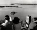
| Date: | 1945 |
|---|---|
| Description: | People on observation tower looking at Sturgeon Bay. |

| Date: | |
|---|---|
| Description: | View of Leathem D. Smith Stone Company, which expanded after 1918. A factory building is in the background, and a steam shovel is working in the foreground... |

| Date: | 1872 |
|---|---|
| Description: | This 1872 map shows the proposed route of a canal between Sturgeon Bay, on the Green Bay side of the Door Peninsula, and Lake Michigan. Depths in both Stur... |

| Date: | 1899 |
|---|---|
| Description: | Map of Door County with inset photograph of Sturgeon Bay City. |

| Date: | 1941 |
|---|---|
| Description: | Elevated view of Sturgeon Bay in 1900. Sturgeon Bay Bridge spans the bay and several boats are on the water. A lighthouse sits on a small island in the bay... |

| Date: | |
|---|---|
| Description: | Aerial view of Potawatomi State Park, with the Sturgeon Bay shoreline in the background. |

| Date: | 06 25 1901 |
|---|---|
| Description: | This map shows beacons, buoys, docks, quarries, streets, and buildings. The map inset shows the Harbor of refuge at entrance to Sturgeon Bay and Lake Michi... |

| Date: | 12 28 1908 |
|---|---|
| Description: | This map shows beacons, buildings, streets, and quarries. Two inset maps include: Vicinity of Sturgeon Bay, Wis. and the Harbor of refuge at entrance to St... |

| Date: | 01 06 1958 |
|---|---|
| Description: | Ahnapee & Western Railway Bridge construction. View is from Highway Bridge. There are ships on the right side beyond the bridge. The forested shoreline cur... |

| Date: | 01 06 1958 |
|---|---|
| Description: | Ahnapee & Western Railway Bridge from north side of frozen Sturgeon Bay. The bridge is made of wood (and steel supports???). There is a dock in the foregro... |

| Date: | |
|---|---|
| Description: | Aerial view of harbors and bridge. Farm fields are on either side of the bridge. The city of Sturgeon Bay is in the distance. There are docks along the sho... |

| Date: | 1967 |
|---|---|
| Description: | View across grass and sand towards a young couple, a man and woman, holding hands and walking along the shoreline of Whitefish Bay. Trees are along the cur... |
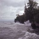
| Date: | |
|---|---|
| Description: | High waves are hitting the rock faces of the shoreline along Lake Michigan. |
If you didn't find the material you searched for, our Library Reference Staff can help.
Call our reference desk at 608-264-6535 or email us at: