Filter: Categories of Wisconsin Historical Images
Filter: Community of Superior
Filter: Subject of human settlements
Filter: Categories of Wisconsin Historical Images
Filter: Community of Superior
Filter: Subject of human settlements

| Date: | 1940 |
|---|---|
| Description: | This ward map shows streets, the Nemadji River, and addition and division boundaries. Also included is a list of members of the Douglas County Board town, ... |

| Date: | 1861 |
|---|---|
| Description: | This map shows lot and block numbers, piers, streets, monuments, and township section corners. Included is a note on the width of avenues, piers, slips, al... |

| Date: | 1900 |
|---|---|
| Description: | This map shows streets, railroads, dock and harbor lines, and parks. The map includes population tables for 1880, 1890, 1900. |

| Date: | 06 30 1893 |
|---|---|
| Description: | This map shows selected industrial buildings, streets, railroads, docks, and beacons in West Duluth, Duluth, West Superior, and Superior, as well as the St... |

| Date: | 1892 |
|---|---|
| Description: | This map shows the St. Louis Bay, Lake Superior, railroads, railroad yards, main roads, additions, and selected buildings in Superior and parts of the Town... |

| Date: | |
|---|---|
| Description: | Aerial view of harbor, with shipyards in the foreground and Superior in the background. Caption reads: "Aerial View of Harbor, Superior, Wisconsin." |
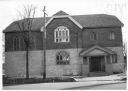
| Date: | 02 1977 |
|---|---|
| Description: | Exterior view from street of the Hebrew Brotherhood Synagogue. |
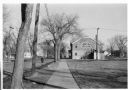
| Date: | 02 1977 |
|---|---|
| Description: | View down sidewalk towards the exterior of the Hebrew Brotherhood Synagogue. |

| Date: | 1990 |
|---|---|
| Description: | This map shows the Minnesota Point, Wisconsin Point, Hog Island, Baker's Island, Connors Point, Blatnik Bridge, Superior Bay, Allouez Bay, the Nemadji Rive... |

| Date: | 1873 |
|---|---|
| Description: | This blueprint map shows water depths by soundings and isolines. To the top left is Duluth, Minnesota. To the bottom right is Superior City, Wisconsin. The... |

| Date: | 1966 |
|---|---|
| Description: | This blue line print shows existing and proposed streets, docks, company-owned land, railroads and railroad yards, parks, and municipal airport. |

| Date: | 1892 |
|---|---|
| Description: | A Sanborn map of St. Louis, which is six miles southwest of South Superior. |
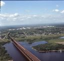
| Date: | 08 1971 |
|---|---|
| Description: | Aerial view of an ore dock next to Hog Island. The town is in the distance. In the far background are the white storage buildings of the oil refinery. |

| Date: | 1899 |
|---|---|
| Description: | Stereograph of President McKinley speaking to a large crowd from a stage decorated with bunting. In the background are buildings and train cars. Caption re... |

| Date: | 07 04 1889 |
|---|---|
| Description: | Elevated view looking south along unpaved Tower Avenue of storefronts, American flags are flying from a number of the commercial buildings. |

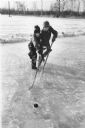
| Date: | 02 1962 |
|---|---|
| Description: | Two children breaking a trail through new snow at a park. Trees are in the background and on the right. |
| Date: | 1915 |
|---|---|
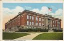
| Description: | Text on front reads: "Central High School, Superior, Wis." The school was built in 1909 of brick in the Neoclassical style. In 1928, President Coolidge use... |
| Date: | 1904 |
|---|---|
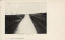
| Description: | Text on front reads: "Ore Docks, Superior, Wis." Elevated view of an ore carrying ship that is within the ore docks on Lake Superior. |

| Date: | 03 23 1915 |
|---|---|
| Description: | Text on front reads: "Steamship William E. Corey, entering Duluth and Superior Harbor, Wis." A steamship entering the harbor under the Aerial Lift Bridge, ... |
If you didn't find the material you searched for, our Library Reference Staff can help.
Call our reference desk at 608-264-6535 or email us at: