 Filter: Categories of Wisconsin Historical Images
Filter: Community of Trempealeau
Filter: Categories of Wisconsin Historical Images
Filter: Community of Trempealeau
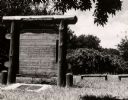
| Date: | 1951 |
|---|---|
| Description: | A marker commemorating the French fort erected by Rene Godefrey, Sieur de Linctot, which exisited on this site between 1731-1736. It is thought that the si... |

| Date: | 07 25 2007 |
|---|---|
| Description: | Open casket of Margaret Brom, during a wake at St. Bart's. |

| Date: | 1925 |
|---|---|
| Description: | View from road of a two-story brick structure identified as the Melchior Hotel. See also image 67069. |

| Date: | 08 05 1925 |
|---|---|
| Description: | The Melchior Hotel on the Mississippi River, with the "brewery at near end." There is a prominent stone portion at right center with several wings or addit... |

| Date: | |
|---|---|
| Description: | View of a flock of turkeys at a turkey farm. A worker can be seen pouring feed into large feed-buckets using a machine. The text on the side of the feed-bu... |

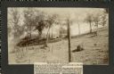
| Date: | 1906 |
|---|---|
| Description: | Group of people stand on pier near the Diamond Jo line steamboat Quincy, sunk in 1906. It was raised and renamed the J.S. There are men on th... |
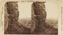
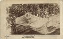
| Date: | 1890 |
|---|---|
| Description: | Stereograph view from the bluffs looking down over a town. A man is standing on the edge of the side of the formation, about halfway up, above treeline, an... |

| Date: | |
|---|---|
| Description: | Three different signs with directions to Perrot State Park are lined up on a bench. |

| Date: | 1854 |
|---|---|
| Description: | This map is mounted on cloth and shows lot and block numbers, streets, additions, and public squares. Also included is information on Trempealeau, an inset... |
| Date: | 1905 |
|---|---|
| Description: | Two of a series of three large platform mounds on the top of a high hill, overlooking the Mississippi and Black River valleys. Two young children are seate... |
| Date: | 1905 |
|---|---|
| Description: | View across top of platform mound on the crest of a high hill. Trees are on the left and right. In the background below is the Mississippi River. |
| Date: | 11 04 1921 |
|---|---|
| Description: | The last, signed page of an 11-page manuscript titled "The Platforms at Trempeleau." |
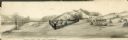
| Date: | |
|---|---|
| Description: | Drawing, with watercolor added, of a French fort next to a body of water with a large hill in the background. There are canoes at the water's edge. Structu... |
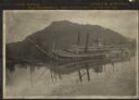
| Date: | 1906 |
|---|---|
| Description: | View across water towards the steamer Quincy, of the Diamond Jo Line, partially sunken into the Mississippi River and listing to port near the shore... |

| Date: | 1920 |
|---|---|
| Description: | This blue print map shows landownership between 1913 and 1916, topography, railroads, and roads. The map covers the vicinity of Perrot State Park. |
| Date: | 1888 |
|---|---|
| Description: | View looking up at three men and a child on top of a cliff on which are petroglyphs. Caption on photograph reads: "Pictograph Rock. Rock bearing aboriginal... |
| Date: | 1888 |
|---|---|
| Description: | View looking up at three men and a child on top of a cliff on which are petroglyphs. Pictograph Rock bearing aboriginal carvings, located on the south side... |
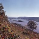
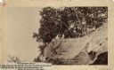
| Date: | 1972 |
|---|---|
| Description: | Elevated view looking south towards the Mississippi River from Brady's Bluff in Perrot State Park. |
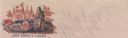
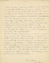
| Date: | 01 28 1862 |
|---|---|
| Description: | Letterhead depicting a scene in the Battle of Big Bethel, in which Lieutenant John T. Greble refused to pull back, as he continued to fire his last cannon.... |
If you didn't find the material you searched for, our Library Reference Staff can help.
Call our reference desk at 608-264-6535 or email us at:
