Filter: Categories of Wisconsin Historical Images
Filter: Community of Waupaca
Filter: Creator Name of Unknown
Filter: Subject of human settlements
Filter: Subject of water
Filter: Categories of Wisconsin Historical Images
Filter: Community of Waupaca
Filter: Creator Name of Unknown
Filter: Subject of human settlements
Filter: Subject of water

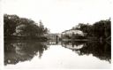
| Date: | 1910 |
|---|---|
| Description: | Aerial view of some of the 26 lakes known collectively as the Chain O' Lakes. Caption reads: "Aeroplane View of Chain O'Lakes, Waupaca, Wis." |
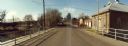
| Date: | 11 16 1989 |
|---|---|
| Description: | View from the Water Street Bridge over the Waupaca River toward the Waupaca Water Department. |
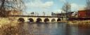
| Date: | 11 16 1989 |
|---|---|
| Description: | Water Street Bridge over the Waupaca River in the city of Waupaca. |

| Date: | 1898 |
|---|---|
| Description: | This 1896 map of the Chain-O-Lakes region of Waupaca County, Wisconsin, shows the lakes and streams, some topography, archaeological sites, roads, railroad... |
If you didn't find the material you searched for, our Library Reference Staff can help.
Call our reference desk at 608-264-6535 or email us at: