Filter: Categories of Wisconsin Historical Images
Filter: Community of Wrightstown
Filter: Categories of Wisconsin Historical Images
Filter: Community of Wrightstown
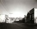
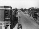
| Date: | 1963 |
|---|---|
| Description: | View down middle of street of the main business district. |
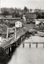
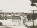
| Date: | 1865 |
|---|---|
| Description: | Elevated view of a bridge and logging debris around residential homes. |
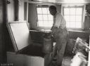
| Date: | 07 08 1936 |
|---|---|
| Description: | A man lifts a milk canister into a McCormick-Deering Milk Cooler. Light from two windows illuminates the room, and buckets sit along the wall opposite the... |
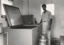
| Date: | 07 08 1936 |
|---|---|
| Description: | A man (identified as Earl Atkinson) stands next to a McCormick-Deering Milk Cooler. A milk container sits at his feet. |

| Date: | 08 04 1962 |
|---|---|
| Description: | A boat in the Fox River Canal, headed up river. This particular lock, the Ripide Croche Lock, is located just north of Wrightstown. |
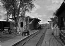
| Date: | |
|---|---|
| Description: | Several men are working on the railroad depot in Camp Dix, which was operated by Adams Express Company. Other men and a woman are standing near the buildin... |
| Date: | 1930 |
|---|---|
| Description: | Elevated view of High Street (Highway 96) and the bridge over the Fox River at Wrightstown. Farmers & Traders Bank is at left, a sign for Meuleman's Elect... |
| Date: | 1908 |
|---|---|
| Description: | Looking down hill southeast across the Fox River bridge. Industrial buildings line the shoreline on the far side. |
| Date: | 10 12 1963 |
|---|---|
| Description: | View from shoreline through trees towards houses on the opposite shoreline along the Fox River. |

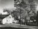
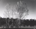
| Date: | 1963 |
|---|---|
| Description: | Street view at sunrise, looking uphill towards commercial buildings. |
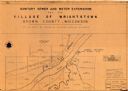
| Date: | 1961 |
|---|---|
| Description: | This map shows a sewage treatment plant site and includes an index of "Title and Index," "Watermain Details," "Sanitary Sewer Details," and "Plan B Profile... |
If you didn't find the material you searched for, our Library Reference Staff can help.
Call our reference desk at 608-264-6535 or email us at: