 Filter: Categories of Wisconsin Historical Images
Filter: County of Adams
Filter: Type of Map or Atlas
Filter: Categories of Wisconsin Historical Images
Filter: County of Adams
Filter: Type of Map or Atlas
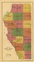
| Date: | 1916 |
|---|---|
| Description: | This early 20th century map of Adams County, Wisconsin, shows the township and range grid, towns, sections, cities and villages, roads, railroads, lakes an... |
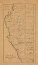
| Date: | 1900 |
|---|---|
| Description: | This map of Adams County, Wisconsin, from E.B. Foote's Plat book of Adams County, Wisconsin, 1900, shows the township and range grid, towns, sections, citi... |

| Date: | 01 01 1856 |
|---|---|
| Description: | This map is mounted on cloth and shows lots, as well as location of the public square and college. Streets are labeled as is the Wisconsin River. |

| Date: | 1855 |
|---|---|
| Description: | This map is ink, pencil, and color on paper and shows property owners, a cemetery, farms, hotels, roads, a dike and on the back are additional notes. Notes... |
If you didn't find the material you searched for, our Library Reference Staff can help.
Call our reference desk at 608-264-6535 or email us at: