 Filter: Categories of Wisconsin Historical Images
Filter: County of Ashland
Filter: Subject of human settlements
Filter: Categories of Wisconsin Historical Images
Filter: County of Ashland
Filter: Subject of human settlements
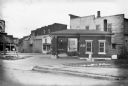
| Date: | 1935 |
|---|---|
| Description: | View of a small brick building, probably a service station, with the word "AIR" painted on the bricks, on the south east corner of 9th Ave. West and 2nd St... |

| Date: | |
|---|---|
| Description: | Aerial view of town, showing the shoreline of Lake Superior, ore docks, roads, houses, buildings, trees, and smokestacks. Text describing this photograph s... |
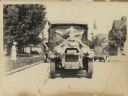
| Date: | 1926 |
|---|---|
| Description: | Front view of a truck decorated for a parade. Manufactured by the White Motor Company, used as a Bamby Bread delivery truck. |
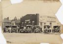
| Date: | 1928 |
|---|---|
| Description: | Six trucks and a car are parked in front of the Central Baking Company. Most of the vehicles are decorated with flags and streamers for a parade. The truck... |
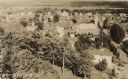
| Date: | 1932 |
|---|---|
| Description: | Aerial view of town looking down from hill lined with trees. In the foreground railroad tracks cross a road. A church building and numerous dwellings are a... |

| Date: | 1896 |
|---|---|
| Description: | This 1896 map shows the township and range system, sections, cities and villages, railroads, roads, vacant land and land sold by the Wisconsin Central Rail... |

| Date: | 1896 |
|---|---|
| Description: | This 1898 map shows the township and range system, sections, cities and villages, railroads, roads, vacant land and land sold by the Wisconsin Central Rail... |

| Date: | 1917 |
|---|---|
| Description: | This 1917 map of Ashland County, Wisconsin, shows the township and range system, towns, sections, cities and villages, the Bad River Indian Reservation, ra... |

| Date: | 1925 |
|---|---|
| Description: | This 1925 map of Ashland County, Wisconsin, shows the township and range system, towns, sections, cities and villages, the Bad River Indian Reservation, ra... |

| Date: | 1977 |
|---|---|
| Description: | This pictorial map was produced by the Chateau, a resort in La Pointe, and shows Madeline Island landmarks and tourist attractions. On the verso is the spr... |

| Date: | 1990 |
|---|---|
| Description: | This tourism brochure of Ashland County, Wisconsin, from the Ashland Area Chamber of Commerce includes a map of the county showing tourist destinations and... |

| Date: | 1886 |
|---|---|
| Description: | This map of Ashland County, Wisconsin, which at the time included part of present-day Iron County, also covers portions of Vilas County, Wisconsin, then pa... |

| Date: | 1890 |
|---|---|
| Description: | This 1890s map shows the Wisconsin Central Railroad land grant lands owned and for sale by the Soo Line in Ashland County, Wisconsin, as well as in the eas... |

| Date: | 1900 |
|---|---|
| Description: | This chart of the northern Apostle Islands and Lake Superior shoreline shows relief by contours and spot heights and depths by contours, gradient tints and... |

| Date: | 1898 |
|---|---|
| Description: | This 1898 map of Ashland County, Wisconsin, shows the township and range grid, towns, sections, cities and villages, landownership, roads, railroads, swamp... |

| Date: | 1964 |
|---|---|
| Description: | This 1964 map of Madeline Island, Ashland County, Wisconsin, shows existing and historical locations, roads, the boundaries of a proposed state park, secti... |
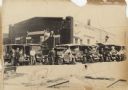
| Date: | 1928 |
|---|---|
| Description: | Six trucks and a car are parked in front of the Central Baking Company building. Most of the vehicles are decorated with flags and streamers for a parade. ... |
| Date: | 1859 |
|---|---|
| Description: | Shows acreages and swamps in a portion of Gordon township, Ashland County, Wis. Originally published as two maps. Township lines surveyed by A.C. Stuntz ; ... |

| Date: | 1989 |
|---|---|
| Description: | At the dedication of the Blue Cross/Blue Shield facilty, Congressman David R. Obey was present to present a flag that had flown over the United States Capi... |

| Date: | 1850 |
|---|---|
| Description: | Map is pen and pencil on paper. The map shows roads, creeks, and the Chequamegon Bay. The map is undated and prepared sometime between the establishment of... |
If you didn't find the material you searched for, our Library Reference Staff can help.
Call our reference desk at 608-264-6535 or email us at: