Filter: Categories of Wisconsin Historical Images
Filter: County of Ashland
Filter: Subject of school buildings
Filter: Categories of Wisconsin Historical Images
Filter: County of Ashland
Filter: Subject of school buildings
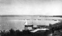
| Date: | 1900 |
|---|---|
| Description: | Elevated view of La Pointe and the shoreline from the Old Mission dock. Two boys and two men stand along the shoreline. The white building with the dark ro... |
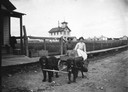
| Date: | 1910 |
|---|---|
| Description: | Two women sitting in dog cart on dirt street in front of boardwalk. La Pointe Village School is in the background. Dog team belongs to Tom Stahl. |
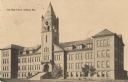
| Date: | 1910 |
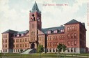
|---|---|
| Description: | The Beaser Avenue School, built in 1899 of brick and brownstone in the Richardson Romanesque style. In the background are dwellings and a church building. ... |
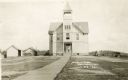
| Date: | 1910 |
|---|---|
| Description: | Front entrance to the public school in Butternut. A wooden sidewalk leads up to the entrance, where a |

| Date: | 1890 |
|---|---|
| Description: | Stereograph of Presbyterian Mission school grounds in the Chippewa Indian reservation. Building in background, boy walking in field in foreground. |

| Date: | 1890 |
|---|---|
| Description: | Stereograph of Presbyterian Mission school. People gathered in front of building. Fence in foreground of photograph. |

| Date: | 1885 |
|---|---|
| Description: | Stereograph. Probably the Presbyterian Mission School grounds on the Chippewa Indian reservation. Two boys and a dog are standing in the foreground, with a... |
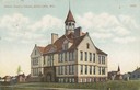
| Date: | |
|---|---|
| Description: | Exterior of the front facade of City High School with bell tower. |

| Date: | 1917 |
|---|---|
| Description: | This 1917 map of Ashland County, Wisconsin, shows the township and range system, towns, sections, cities and villages, the Bad River Indian Reservation, ra... |

| Date: | 1925 |
|---|---|
| Description: | This 1925 map of Ashland County, Wisconsin, shows the township and range system, towns, sections, cities and villages, the Bad River Indian Reservation, ra... |

| Date: | 1890 |
|---|---|
| Description: | This map shows the Wisconsin Central Railroad land grant lands owned and for sale by the Soo Line in Ashland County, Wisconsin, as well as in portions of B... |

| Date: | 1890 |
|---|---|
| Description: | This 1890s map shows the Wisconsin Central Railroad land grant lands owned and for sale by the Soo Line in Ashland County, Wisconsin, as well as in the eas... |

| Date: | 1898 |
|---|---|
| Description: | This 1898 map of Ashland County, Wisconsin, shows the township and range grid, towns, sections, cities and villages, landownership, roads, railroads, swamp... |

| Date: | 1909 |
|---|---|
| Description: | This map shows vacant Wisconsin Central Ry. lands, settlers houses, lands sold by Wisconsin Central Ry., schools, churches, saw mills, and roads; also show... |
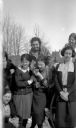
| Date: | |
|---|---|
| Description: | Outdoor group portrait of seven female students at Northland College. A few of the women are holding donuts, and a woman in the center is getting ready to ... |
If you didn't find the material you searched for, our Library Reference Staff can help.
Call our reference desk at 608-264-6535 or email us at: