 Filter: Categories of Wisconsin Historical Images
Filter: County of Bayfield
Filter: Subject of transportation
Filter: Community of Drummond
Filter: Categories of Wisconsin Historical Images
Filter: County of Bayfield
Filter: Subject of transportation
Filter: Community of Drummond
| Date: | 1938 |
|---|---|
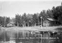
| Description: | Cabins on shoreline of Upper Eau Claire Lake at Lyndale Bay Resort. |
| Date: | 1938 |
|---|---|
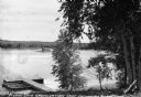
| Description: | Cabins around clearing in the woods at Lyndale Bay Resort on Upper Eau Claire Lake. |
| Date: | 1937 |
|---|---|
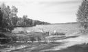
| Description: | Canoes and lawn chairs at the shore of Upper Eau Claire Lake. Caption reads: "Big Eau Claire Lake From Taylors Cabins, Drummond, Wis." |

| Date: | 1968 |
|---|---|
| Description: | The map shows fire towers, public camp grounds, roads, snow mobile & riding trails, trout lakes, foot trails, railroads, and National Forest boundaries. |
| Date: | 1930 |
|---|---|
| Description: | View down hill of Pigeon Lake with four boats at the dock. Trees surround the lake at Pigeon Lake Organization Camp in the Chequamegon National Forest. |
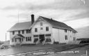
| Date: | 1936 |
|---|---|
| Description: | Exterior three-quarter length view of a large two-story building with one chimney. There are two main entrances with steps leading up to the doorways of wh... |
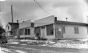
| Date: | 1937 |
|---|---|
| Description: | View across road of a man and a dog standing on the front stoop of a one-story building that has a sign that reads “Art’s Lunches and Confectionery, Ask fo... |
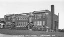
| Date: | 1935 |
|---|---|
| Description: | Exterior view of a two-story brick building, the Drummond High School. There is some decoration around the windows, front doors, and in the brickwork. The ... |
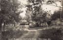
| Date: | 1933 |
|---|---|
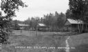
| Description: | Four automobiles parked at the top of a dirt drive at Pease Resort on Upper Eau Claire Lake. On the far right is a shed or garage, and on the left are tree... |
| Date: | 1930 |
|---|---|
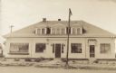
| Description: | Exterior view of the front facade of a building. The left side has a sign that says: "State Bank of Drummond" and the window on the right says: "Soda and I... |

| Date: | 1917 |
|---|---|
| Description: | This map, which highlights the land for sale by the Rust-Owen Lumber Company in the towns of Drummond, Cable and Grandview, Bayfield County, Wisconsin, sho... |

| Date: | 1910 |
|---|---|
| Description: | This map is ink and pen on tracing cloth and shows plat of the town, local streets, county roads, railroads, school houses, town halls, hotels, sheds, barn... |

| Date: | 1919 |
|---|---|
| Description: | This map is a topographical map and has relief shown by contours. The map shows roads, state highways, hotels, town halls, school houses, stores, barns, de... |
| Date: | 1920 |
|---|---|
| Description: | View across snowy ground towards a steam-belching train engine on the right pulling flatbeds of stacked logs near a forest of tall pines. Caption reads: "L... |
| Date: | 1920 |
|---|---|
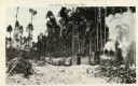
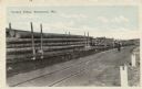
| Description: | View across railroad tracks towards train flatbeds stacked with large pine logs. There is a man standing further down the tracks looking towards the flatbe... |
If you didn't find the material you searched for, our Library Reference Staff can help.
Call our reference desk at 608-264-6535 or email us at: