 Filter: Categories of Wisconsin Historical Images
Filter: County of Bayfield
Filter: Subject of transportation
Filter: Categories of Wisconsin Historical Images
Filter: County of Bayfield
Filter: Subject of transportation

| Date: | 1933 |
|---|---|
| Description: | View looking down tree-lined road and birch log fence. The road is along a shoreline and leads to the Lakewoods Country Club. Three buildings are along a l... |
| Date: | 1934 |
|---|---|
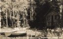
| Description: | View from water towards shoreline of two boats at Les Crandall's Housekeeping Cottages on Lake Namakagon tied up in front of two log cabins. A deer (not kn... |

| Date: | 1900 |
|---|---|
| Description: | This 1900 map shows the township and range system, sections, cities and villages, railroads, roads, vacant land and land sold by the Wisconsin Central Rail... |

| Date: | 1871 |
|---|---|
| Description: | Asaph Whittlesey arrived in Ashland in 1854, one of the earliest of the settlers who hoped the area would grow and make their fortunes. He drew this map of... |

| Date: | 1952 |
|---|---|
| Description: | This 1952 map of the northern parts of Bayfield and Douglas counties, Wisconsin, shows points established by E.T. Sweet in 1877, road points confirmed by S... |

| Date: | 1952 |
|---|---|
| Description: | This map of the northern parts of the Chequamegon Bay area in Bayfield and Ashland counties, Wisconsin, shows trails, roads, railroads, stations, the towns... |

| Date: | 1917 |
|---|---|
| Description: | This map, which highlights the land for sale by the Rust-Owen Lumber Company in the towns of Drummond, Cable and Grandview, Bayfield County, Wisconsin, sho... |

| Date: | 1917 |
|---|---|
| Description: | This 1917 map of Bayfield County, Wisconsin, shows the township and range system, towns, sections, cities and villages, railroads, wagon roads, and lakes a... |

| Date: | 1935 |
|---|---|
| Description: | This pictorial map of northern Bayfield County, Wisconsin, shows the Chequamegon National Forest, the Red Cliff Indian Reservation, highways and roads, and... |

| Date: | 1871 |
|---|---|
| Description: | Asaph Whittlesey arrived in Ashland in 1854, one of the earliest of the settlers who hoped the area would grow and make their fortunes. He drew this map of... |

| Date: | 1906 |
|---|---|
| Description: | This 1906 map of Bayfield County, Wisconsin, shows towns, sections, cities, villages and post offices, land ownership, wagon roads, railroads, schools, gov... |

| Date: | 1967 |
|---|---|
| Description: | This tourist brochure for Bayfield County, Wisconsin, from 1967 includes a map of the county showing towns, cities and villages, highways and roads, railro... |

| Date: | 1920 |
|---|---|
| Description: | This manuscript map of southern Bayfield County, Wisconsin, covers the towns of Cable and Drummond and portions of Grandview and Namekagon. Shown are the t... |
| Date: | 1931 |
|---|---|
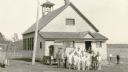
| Description: | Pupils and their teacher (rear) pose in front of their school house. Two cars are parked in the school yard. A man and other pupils stand near a water pump... |
| Date: | 1931 |
|---|---|
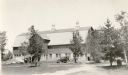
| Description: | An automobile is parked near the Melvin Larson barn in Bayfield County. The large barn has a concrete block foundation, gambrel roof, and three large venti... |
| Date: | |
|---|---|
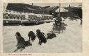
| Description: | Dogsled team and their driver in front of a loading dock stacked with barrels. Caption reads: "Tote Team, Bayfield, Wis." |
| Date: | |
|---|---|
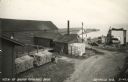
| Description: | Photographic postcard of an elevated view of the fishery and its dock. Caption reads: "View of Booth Fisheries Dock." |
| Date: | 1950 |
|---|---|
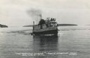
| Description: | Photographic postcard view of a fishing boat in Lake Superior with tourists on board. There is an island on the horizon. Caption reads: "'The Apostle Isla... |
| Date: | |
|---|---|
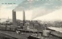
| Description: | Elevated view of the saw mill. Lumber is stacked in front of several buildings and railroad tracks. Caption reads: "Saw Mill, Bayfield, Wis." |
| Date: | |
|---|---|
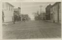
| Description: | View down center of Rittenhouse Avenue with Lake Superior in the distance. The street is lined with businesses, sidewalks and lampposts. |
If you didn't find the material you searched for, our Library Reference Staff can help.
Call our reference desk at 608-264-6535 or email us at: