 Filter: Categories of Wisconsin Historical Images
Filter: County of Bayfield
Filter: Subject of transportation
Filter: Categories of Wisconsin Historical Images
Filter: County of Bayfield
Filter: Subject of transportation
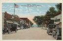
| Date: | |
|---|---|
| Description: | Colorized postcard view down a street (Rittenhouse Avenue) to Lake Superior. The street is lined with businesses and parked cars. Caption reads: "Street Sc... |
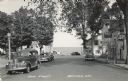
| Date: | 1950 |
|---|---|
| Description: | Photographic postcard view down Main Street, with Lake Superior in the distance. There is a cafe on the left and bars on the right. Cars are parked along t... |
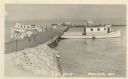
| Date: | 1949 |
|---|---|
| Description: | Photographic postcard view of the City Dock on Lake Superior. There are four boats, and people and cars are on the dock. A sign in the foreground reads: "N... |
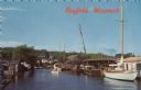
| Date: | |
|---|---|
| Description: | Photographic postcard view from water of a marina. Sailboats and motorboats are docked. More boats are stored up on the shoreline. Trees and buildings are ... |

| Date: | |
|---|---|
| Description: | Color postcard of view across water towards the "Nichevo II" ferry for Bayfield-Madeline Island moving through the water and filled with tourists and their... |

| Date: | |
|---|---|
| Description: | View from water of a log rolling contest. One man is still upright and the other has fallen into the water. A boat is visible to the left and trees line th... |
| Date: | |
|---|---|
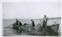
| Description: | Four fishermen in a boat lift nets on Lake Superior. The far shoreline is in the background. |

| Date: | 1856 |
|---|---|
| Description: | This map of Bayfield shows a plat of the town, roads, and part of Lake Superior. Relief is shown by hachures. The right margin of the map includes illustra... |

| Date: | 1892 |
|---|---|
| Description: | This map of Bayfield shows roads, lots, and township boundaries. The map was originally published on one sheet but is now separated into front and back. On... |
| Date: | 1858 |
|---|---|
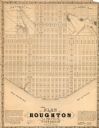
| Description: | This map is a proposed plan for a town that was never built located in present day Bayfield county, showing street names and with numbered blocks and lots.... |

| Date: | 1910 |
|---|---|
| Description: | This map is ink and pen on tracing cloth and shows plat of the town, local streets, county roads, railroads, school houses, town halls, hotels, sheds, barn... |

| Date: | 1919 |
|---|---|
| Description: | This map is a topographical map and has relief shown by contours. The map shows roads, state highways, hotels, town halls, school houses, stores, barns, de... |

| Date: | 1856 |
|---|---|
| Description: | This map shows land ownership by name, a plat of Bayfield, local streets, part of Lake Superior, part of Madeline Island, and part of Bass Island. La Point... |

| Date: | 1971 |
|---|---|
| Description: | A topgraphical map of Cable, Wisconsin showing railroads. |

| Date: | 1971 |
|---|---|
| Description: | A topographical map of Namekagon Lake and the surrounding area. |

| Date: | |
|---|---|
| Description: | Three women stand on the shore in front of the steamer Barker at Devils Island natural dock. |
| Date: | 1920 |
|---|---|
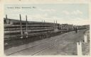
| Description: | View across snowy ground towards a steam-belching train engine on the right pulling flatbeds of stacked logs near a forest of tall pines. Caption reads: "L... |
| Date: | 1920 |
|---|---|
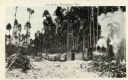
| Description: | View across railroad tracks towards train flatbeds stacked with large pine logs. There is a man standing further down the tracks looking towards the flatbe... |
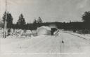
| Date: | 1935 |
|---|---|
| Description: | Winter scene with a V-blade snowplow from the front plowing snow from a road. The snow is billowing to the left side of the road in a large arc. Trees are... |
If you didn't find the material you searched for, our Library Reference Staff can help.
Call our reference desk at 608-264-6535 or email us at:
