 Filter: Categories of Wisconsin Historical Images
Filter: County of Bayfield
Filter: Subject of transportation
Filter: Categories of Wisconsin Historical Images
Filter: County of Bayfield
Filter: Subject of transportation
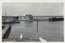
| Date: | 06 19 1958 |
|---|---|
| Description: | Slightly elevated view of Cornucopia Harbor. There is a boat moored at a pier near a barn-shaped building. An automobile is parked on the far left. In the ... |
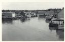
| Date: | 06 19 1958 |
|---|---|
| Description: | Slightly elevated view over water towards East slip in Cornucopia Harbor. There is a small cluster of buildings along the left and right sides with boats m... |
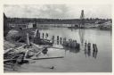
| Date: | 06 19 1958 |
|---|---|
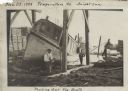
| Description: | View over water towards storm damage in Cornucopia Harbor. West slip. There is a pile of wood along the shoreline in the foreground, with a boat moored jus... |
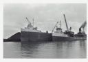
| Date: | |
|---|---|
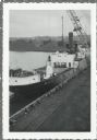
| Description: | View across water towards ships unloading coal and sulphur. Cranes rise above both ships, and a man is walking near a large pile of coal in the background ... |
| Date: | |
|---|---|
| Description: | Elevated view over railroads tracks of Canadian ship with cargo of wood pulp. Sulphide bales are being unloaded and there are several men on the ship. In t... |
| Date: | 1916 |
|---|---|
| Description: | View across Lake Superior towards Bayfield. |

| Date: | 1935 |
|---|---|
| Description: | This topographical map of the forest preserve shows highways, roads, trails, telephone lines, Native American reservations, Ranger sub-stations, state nurs... |

| Date: | 1912 |
|---|---|
| Description: | This map shows a school reserve, swamp land, railroads, and selected buildings. |

| Date: | 1918 |
|---|---|
| Description: | Manuscript map of the Chequamegon Bay area on Lake Superior drawn by Warren W. Witmer and illustrated with sketches by Mary L. Wright Witmer in ink and wat... |

| Date: | 1990 |
|---|---|
| Description: | This map shows various types of trails, boat landings, canoe areas, public beaches, picnic areas, campgrounds, golf courses, public tennis courts, and othe... |

| Date: | 2000 |
|---|---|
| Description: | This map shows national parks, county and state forests, Indian reservations, municipal land, private land, docks, boat access, camping, and points of inte... |

| Date: | 1929 |
|---|---|
| Description: | Aerial view of Lake Namakagon, showing the roads that connect Anderson Island (center left), and Juneks Point, Eagle Point, and Paines Island. |
| Date: | 11 29 1908 |
|---|---|
| Description: | Men working on pulling the boat "Fish Hawk" out of the water. One man is kneeling in front of the boat and looking at the camera. A man in the background i... |

| Date: | 1924 |
|---|---|
| Description: | A school bus pulled by a team of horses named Colonel and Ned. |

| Date: | |
|---|---|
| Description: | Color reproduction of a spruce tree with an automobile parked beneath it. Text on reverse reads: "Located on the south shore of Lake Superior, near Herbs... |

| Date: | |
|---|---|
| Description: | A man is sitting on a stool in the open doorway of a small tent on the ice on Lake Owen. He is holding a wooden drop line over a hole in the ice. Behind th... |
| Date: | |
|---|---|
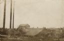
| Description: | View of a sawmill. A man is standing near a horse on the right. The building in the back has many broken windows. Caption reads: "Mill Scene, Kelly, Wiscon... |

| Date: | |
|---|---|
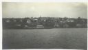
| Description: | View looking downhill between two boys in the foreground sitting on logs on the left and right. Another person is walking up the hill path. Below is a grou... |
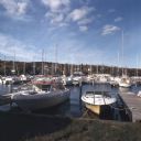
| Date: | 10 1978 |
|---|---|
| Description: | View from shoreline towards motorboats and sailboats docked in a marina. In the distance are buildings on a hill among trees. |
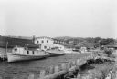
| Date: | 07 1936 |
|---|---|
| Description: | Fishing tugs are moored alongside the wharf at Bayfield. The large Bayfield Fish Co. building is identified in large letters on the end of the building. Th... |
If you didn't find the material you searched for, our Library Reference Staff can help.
Call our reference desk at 608-264-6535 or email us at: