 Filter: Categories of Wisconsin Historical Images
Filter: County of Bayfield
Filter: Categories of Wisconsin Historical Images
Filter: County of Bayfield

| Date: | |
|---|---|
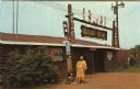
| Description: | View of the exterior of Le Chateau Boutin during peak fall color. |
| Date: | |
|---|---|
| Description: | View of the exterior of the "Indian Bowl," a venue for powwows. A Native American woman is standing in front next to the totems. |
| Date: | |
|---|---|
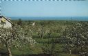
| Description: | Elevated view of an orchard during apple blossom season, with Lake Superior in the distance. |

| Date: | |
|---|---|
| Description: | View from water of a log rolling contest. One man is still upright and the other has fallen into the water. A boat is visible to the left and trees line th... |
| Date: | |
|---|---|
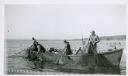
| Description: | Four fishermen in a boat lift nets on Lake Superior. The far shoreline is in the background. |

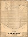
| Date: | 1856 |
|---|---|
| Description: | This map of Bayfield shows a plat of the town, roads, and part of Lake Superior. Relief is shown by hachures. The right margin of the map includes illustra... |

| Date: | 1892 |
|---|---|
| Description: | This map of Bayfield shows roads, lots, and township boundaries. The map was originally published on one sheet but is now separated into front and back. On... |
| Date: | 1858 |
|---|---|
| Description: | This map is a proposed plan for a town that was never built located in present day Bayfield county, showing street names and with numbered blocks and lots.... |

| Date: | 1910 |
|---|---|
| Description: | This map is ink and pen on tracing cloth and shows plat of the town, local streets, county roads, railroads, school houses, town halls, hotels, sheds, barn... |

| Date: | 1919 |
|---|---|
| Description: | This map is a topographical map and has relief shown by contours. The map shows roads, state highways, hotels, town halls, school houses, stores, barns, de... |

| Date: | |
|---|---|
| Description: | Exterior of the menu for Paul's Cafe, with a bird's-eye view map of "Washburn's Natural Deep Water Land Locked Harbor," Chequamegon Bay, and the Apostle Is... |
| Date: | |
|---|---|
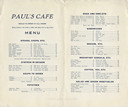
| Description: | Interior of the Paul's Cafe menu, with "Meals to order at all hours." |

| Date: | 1856 |
|---|---|
| Description: | This map shows land ownership by name, a plat of Bayfield, local streets, part of Lake Superior, part of Madeline Island, and part of Bass Island. La Point... |

| Date: | 1971 |
|---|---|
| Description: | A topgraphical map of Cable, Wisconsin showing railroads. |

| Date: | 1971 |
|---|---|
| Description: | A topographical map of Namekagon Lake and the surrounding area. |

| Date: | 07 2001 |
|---|---|
| Description: | David Obey poses with Park Ranger Geoffrey Smith on the left and Martin Hanson on the right. They are standing on the beach with water and land in the back... |

| Date: | 1979 |
|---|---|
| Description: | David and Joan Obey (right) with Senator Gaylord Nelson (2nd from left) and Secretary of the Interior Cecil Andrus (on Nelson's left) on an Apostle Islands... |

| Date: | 1950 |
|---|---|
| Description: | Photographic postcard of a man holding a rifle, squatting on ground on the right, with his trophies: Carcasses of a deer, a bear and a wolf hanging from pi... |

| Date: | 1950 |
|---|---|
| Description: | Photographic postcard of a white painted, wood frame Immanuel Lutheran Church. Sign out front. Sent Sept. 15, 1965, to thank visitors from Eau Claire for c... |

| Date: | |
|---|---|
| Description: | Three women stand on the shore in front of the steamer Barker at Devils Island natural dock. |
If you didn't find the material you searched for, our Library Reference Staff can help.
Call our reference desk at 608-264-6535 or email us at: