 Filter: Categories of Wisconsin Historical Images
Filter: County of Chippewa
Filter: Community of Cornell
Filter: Subject of water
Filter: Categories of Wisconsin Historical Images
Filter: County of Chippewa
Filter: Community of Cornell
Filter: Subject of water
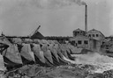
| Date: | 1913 |
|---|---|
| Description: | Dam and hydroelectric power house, with a billowing smokestack and a crane in the background. |

| Date: | 1867 |
|---|---|
| Description: | Drawn map showing planned development of Cornell, including a couple of schools, Oakwood cemetery, the public square, and several bridges and dams. |
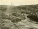
| Date: | 1908 |
|---|---|
| Description: | Brunette Falls on the Chippewa River. Several logs are jammed on a rock formation in the river. |
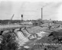
| Date: | |
|---|---|
| Description: | Elevated view across dirt road of a paper mill on the shore of the Chippewa River next to a concrete dam. The mill has a tall smokestack. On the far shorel... |
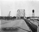
| Date: | 1927 |
|---|---|
| Description: | View down middle of metal bridge across the Cornell Flowage. Across the lake, there is the pulpwood stacker on the left and a water tower on the right near... |
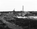
| Date: | 1927 |
|---|---|
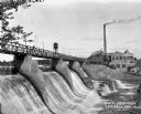
| Description: | View across lower section of dam at Cornell Wood Products Company. In the background are factory buildings, a tall smokestack, and a water tower. |
| Date: | 1927 |
|---|---|
| Description: | Elevated view over dam of the site of the Cornell Wood Products Company. On the opposite shoreline is a pulpwood stacker, tall smokestack, water tower, and... |
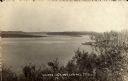
| Date: | 1910 |
|---|---|
| Description: | Elevated view of the Chippewa River. Caption reads: "Chippewa River, Cornell, Wis." |
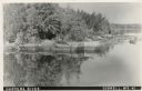
| Date: | 1910 |
|---|---|
| Description: | Elevated view of the Chippewa River. Caption reads: "Chippewa River, Cornell, Wis." |

| Date: | 1912 |
|---|---|
| Description: | This blueprint manuscript map shows landownership, mills, railroad, churches, public buildings, the old cemetery, and the Chippewa River and Reservoir. The... |
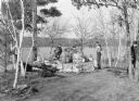
| Date: | 1940 |
|---|---|
| Description: | Boys are roasting weiners at a stone fire ring overlooking the Chippewa River in Brunet Island State Park. A man on the far right, behind trees, is walking... |
If you didn't find the material you searched for, our Library Reference Staff can help.
Call our reference desk at 608-264-6535 or email us at: