 Filter: Categories of Wisconsin Historical Images
Filter: County of Columbia
Filter: Type of Map or Atlas
Filter: Year of 1800-1899
Filter: Year of 1830-1839
Filter: Categories of Wisconsin Historical Images
Filter: County of Columbia
Filter: Type of Map or Atlas
Filter: Year of 1800-1899
Filter: Year of 1830-1839

| Date: | 1830 |
|---|---|
| Description: | Fort Winnebago from an original drawing by Jefferson Davis. |
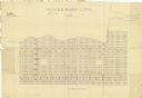
| Date: | 1836 |
|---|---|
| Description: | This map shows proposed lot and block numbers for a paper city located in township 10 north, range 7 east, Wisconsin Territory, now the Town of West Point,... |
| Date: | 1830 |
|---|---|
| Description: | This plat map is pen-and-ink on tracing paper and shows a paper city planned in the late 1830's located on the shore of Swan Lake, Columbia County, Wiscons... |

| Date: | 11 1836 |
|---|---|
| Description: | This map is pen-and-ink on paper and is a plat of a paper city on the Wisconsin River, in what is now the Town of Dekorra. The map shows lot and block numb... |

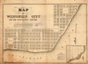
| Date: | 1836 |
|---|---|
| Description: | This map shows lot and block numbers, streets, a proposed canal basin, Fort Winnebago, and the Wisconsin and Fox Rivers. Relief is shown by hachures and no... |
If you didn't find the material you searched for, our Library Reference Staff can help.
Call our reference desk at 608-264-6535 or email us at: