Filter: Categories of Wisconsin Historical Images
Filter: County of Crawford
Filter: Subject of farms
Filter: Categories of Wisconsin Historical Images
Filter: County of Crawford
Filter: Subject of farms
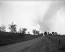
| Date: | 09 09 1961 |
|---|---|
| Description: | View down a country road with fences on both sides. In the distant sky, a cumulonimbus cloud is backlit by the sun. A farm with a barn and silo is on the r... |
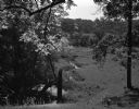
| Date: | 07 04 1965 |
|---|---|
| Description: | A rural valley with a stream running through the pasture. In the background, a farm is visible through the trees. |
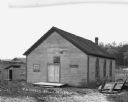
| Date: | |
|---|---|
| Description: | Exterior of the one-room United Brethren [?] Church. There is an outhouse to the left of the church. On the right is a hill with trees. Farm building and a... |

| Date: | |
|---|---|
| Description: | Elevated view of cattle in several pens situated on a hillside. There are also several sheds. Text below reads "Stock Day, Bridgeport, Wis." |
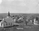
| Date: | 1910 |
|---|---|
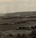
| Description: | Elevated view from hill of Mount Sterlings's churches, homes, and businesses. |
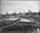
| Date: | 06 12 1915 |
|---|---|
| Description: | People standing among the broken remains of the Tim Finley farm after a killer tornado. A woman in the center is standing on a mattress. Two people were ki... |
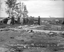
| Date: | 06 12 1915 |
|---|---|
| Description: | Group of men and boys standing around the exposed foundation of a house in the foreground. There is part of an overturned roof on the left. Broken wood is ... |
| Date: | 1915 |
|---|---|
| Description: | Elevated view of the Mississippi River from a bluff. There is a farm and other houses along the shoreline, and in the foreground a boy stands on the bluff ... |

| Date: | 2004 |
|---|---|
| Description: | Holstein cows resting on a sunny day in a hilltop pasture. View to horizon towards wooded hills with clouds in the sky. |

| Date: | 1830 |
|---|---|
| Description: | This map is ink, color, and pencil on paper and shows streets, farm lots, and a church. Handwritten notes are at the bottom of the map and are very light. |

| Date: | 1838 |
|---|---|
| Description: | This map is a development plat that shows street names, numbered blocks and lots, and small farm lot owners. Included on the right of the map is a large am... |

| Date: | 1857 |
|---|---|
| Description: | This map shows lots and streets and includes pencil manuscript notations on the front and certification statements on the reverse. The top left margin read... |

| Date: | 09 01 1856 |
|---|---|
| Description: | This map is pen-and-ink and shows farm lots, other lots of land sectioned by acres, bluffs, and a coulee. Also included are notations in pencil and blue in... |

| Date: | 1855 |
|---|---|
| Description: | This map shows streets and lots. The right side of the map includes notes on widths of streets and certifications. The top right reads: "Parish's Addition ... |
| Date: | |
|---|---|
| Description: | This map shows farm lots and private land claims on Prairie du Chien. The bottom left margin reads: "Part of sec. 1, T6 N, R 7W and sec. 36, T 7N, R 7W. S... |

| Date: | 1865 |
|---|---|
| Description: | This is a collection of two plat maps. The first map shows lots, streets, and farm lot 25. Written in ink, the top of the map reads: Plat of Prairie du Chi... |
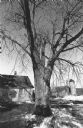
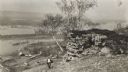
| Date: | 1982 |
|---|---|
| Description: | A large soft maple tree stands beside a small house with plastic sheeting on the porch screens. There is a barn with a silo in the background, and snow on ... |
If you didn't find the material you searched for, our Library Reference Staff can help.
Call our reference desk at 608-264-6535 or email us at: