 Filter: Categories of Wisconsin Historical Images
Filter: County of Crawford
Filter: Subject of lakes
Filter: Categories of Wisconsin Historical Images
Filter: County of Crawford
Filter: Subject of lakes

| Date: | |
|---|---|
| Description: | Boys swimming in a lake pose for a photograph as others sit in a rowboat behind them. |

| Date: | 1878 |
|---|---|
| Description: | This map of Crawford County, Wisconsin, shows the township and range grid, sections, towns, cities and villages, land ownership and acreages, roads, railro... |

| Date: | 01 15 1929 |
|---|---|
| Description: | Intended for tourists, this brochure, titled: "Winneshiek World’s Famous Wild Life Refuge Historic Fort Crawford and Picturesque Prairie du Chien," feature... |

| Date: | 1900 |
|---|---|
| Description: | This map shows a line, marked with latitude and longitude coordinates that runs through Prairie du Chien. Only a few features beyond this line are displaye... |
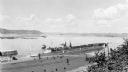
| Date: | 08 1940 |
|---|---|
| Description: | Elevated view of a coal barge pushed by a stern wheeled steamboat heading upstream from the Mississippi River Lock and Dam No. 9 north of Prairie du Chien,... |
If you didn't find the material you searched for, our Library Reference Staff can help.
Call our reference desk at 608-264-6535 or email us at: