Filter: Categories of Wisconsin Historical Images
Filter: County of Dodge
Filter: Year of 1800-1899
Filter: Subject of human settlements
Filter: Year of 1890-1899
Filter: Categories of Wisconsin Historical Images
Filter: County of Dodge
Filter: Year of 1800-1899
Filter: Subject of human settlements
Filter: Year of 1890-1899

| Date: | 1892 |
|---|---|
| Description: | This bird's-eye view map is oriented looking north-east and includes index of points of interest and businesses. The map is a photocopy. |

| Date: | 1896 |
|---|---|
| Description: | This late 19th-century map of Dodge County, Wisconsin, shows the township and range grid, towns, sections, cities, villages and post offices, some property... |

| Date: | 1899 |
|---|---|
| Description: | This 1899 map of Dodge County, Wisconsin, shows the township and range grid, towns, sections, cities and villages, roads, railroads, post offices, cemeteri... |

| Date: | 1893 |
|---|---|
| Description: | The Goetsch sisters sit and stand in two rows on the family farm. They are wearing dark dresses. Names: (back row) Martha G. Buelke, unidentified, Lydia; (... |
| Date: | 1898 |
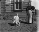
|---|---|
| Description: | Exterior portrait of a woman, a small girl and a dog standing in front of a wooden building. A weathered Fourth of July poster is pasted on the side of the... |

| Date: | 1891 |
|---|---|
| Description: | This map shows soft marshland, water channels, solid ground, club boundary and shooting boxes. Big Lake, First Channel, Second Channel, Fout Mile Pond, Mal... |
If you didn't find the material you searched for, our Library Reference Staff can help.
Call our reference desk at 608-264-6535 or email us at: