 Filter: Categories of Wisconsin Historical Images
Filter: County of Dodge
Filter: Year of 1800-1899
Filter: Subject of transportation
Filter: Year of 1890-1899
Filter: Categories of Wisconsin Historical Images
Filter: County of Dodge
Filter: Year of 1800-1899
Filter: Subject of transportation
Filter: Year of 1890-1899

| Date: | 1892 |
|---|---|
| Description: | This bird's-eye view map is oriented looking north-east and includes index of points of interest and businesses. The map is a photocopy. |

| Date: | 1896 |
|---|---|
| Description: | This late 19th-century map of Dodge County, Wisconsin, shows the township and range grid, towns, sections, cities, villages and post offices, some property... |

| Date: | 1899 |
|---|---|
| Description: | This 1899 map of Dodge County, Wisconsin, shows the township and range grid, towns, sections, cities and villages, roads, railroads, post offices, cemeteri... |
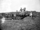
| Date: | 08 1898 |
|---|---|
| Description: | August and Alexander Krueger loading hay with pitchforks onto a wagon with a two-horse team attached. August is standing on top of the wagon while Alexande... |
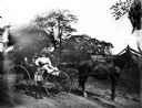
| Date: | 1899 |
|---|---|
| Description: | Sarah Krueger and five Hable children riding a horse-drawn buggy down a road. Sarah is holding the reins. |
If you didn't find the material you searched for, our Library Reference Staff can help.
Call our reference desk at 608-264-6535 or email us at:
