 Filter: Categories of Wisconsin Historical Images
Filter: County of Jefferson
Filter: Year of 1900-1999
Filter: Type of Map or Atlas
Filter: Year of 1900-1909
Filter: Categories of Wisconsin Historical Images
Filter: County of Jefferson
Filter: Year of 1900-1999
Filter: Type of Map or Atlas
Filter: Year of 1900-1909

| Date: | 1900 |
|---|---|
| Description: | A map of Jefferson County, Wisconsin, that identifies named hills, other points of interest, and the Lake Mills moraine system in the county and identifies... |
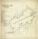
| Date: | 06 30 1907 |
|---|---|
| Description: | Map is ink on tracing paper. The left margin has an index of archeological sites around Koshkonong Lake. Lake Koshkonong is labelled. |

| Date: | 04 1901 |
|---|---|
| Description: | A Sanborn map of Watertown, including an index and a key. |
If you didn't find the material you searched for, our Library Reference Staff can help.
Call our reference desk at 608-264-6535 or email us at: