 Filter: Categories of Wisconsin Historical Images
Filter: County of Jefferson
Filter: Year of 1900-1999
Filter: Type of Map or Atlas
Filter: Year of 1940-1949
Filter: Categories of Wisconsin Historical Images
Filter: County of Jefferson
Filter: Year of 1900-1999
Filter: Type of Map or Atlas
Filter: Year of 1940-1949

| Date: | 1947 |
|---|---|
| Description: | An ink on paper, hand-drawn map of Jefferson County, Wisconsin, that identifies named hills, other points of interest, and the Lake Mills moraine system in... |

| Date: | 1947 |
|---|---|
| Description: | Lower left hand corner features a legend. "Drawn 1938, revised 1947." Shows water mains, hydrants, corporation limits, city ward divisions, fire proof buil... |
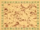
| Date: | 1940 |
|---|---|
| Description: | This map of Watertown pictorially shows historic buildings, locations, and events with dates. The map is printed in brown ink with the border printed in gr... |

| Date: | 1940 |
|---|---|
| Description: | This map of Aztalan is pencil and ink on paper. The map shows streets, local businesses, churches, houses, and the Crawfish River. The map reads: "Informat... |

| Date: | 1941 |
|---|---|
| Description: | This map is ink and watercolor on cardboard and shows Native American legends and villages pictorially. Trails are also shown. |
If you didn't find the material you searched for, our Library Reference Staff can help.
Call our reference desk at 608-264-6535 or email us at: