Filter: Categories of Wisconsin Historical Images
Filter: County of Lafayette
Filter: Creator Name of Unknown
Filter: Subject of industries
Filter: Categories of Wisconsin Historical Images
Filter: County of Lafayette
Filter: Creator Name of Unknown
Filter: Subject of industries
| Date: | 1900 |
|---|---|
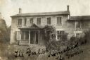
| Description: | View of the Gratiot homestead at Gratiot's Grove Site. |
| Date: | 1900 |
|---|---|
| Description: | Exterior view of the Gratiot homestead at Gratiot's Grove Site. Handwriting on front reads: "The Gratiot Homestead at the (?)on." |
| Date: | |
|---|---|
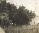
| Description: | View of Marty's Warehouse from across railroad tracks. The warehouse building has large signs of painted lettering advertising the storage facilities. Rail... |
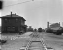
| Date: | 1925 |
|---|---|
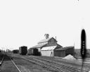
| Description: | View down railroad tracks of a locomotive pulling into a railroad depot and yards. The depot is a two-story building. Two wagons are parked near the depot ... |
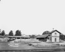
| Date: | |
|---|---|
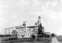
| Description: | Elevated view across railroad tracks of a lumber yard. A two-story building on the right has a sign that says: "Lovejoy & Ringham". There are fences, a sto... |

| Date: | 1932 |
|---|---|
| Description: | Several old timbers are exposed on Mud Branch Road. A one-mile stretch of the road was originally constructed as a corduroy road because of "quick sand" in... |

| Date: | 1857 |
|---|---|
| Description: | This map shows lot numbers, lot dimensions (in chains and links), and a mineral reservation for use of proprietors. Includes certifications signed in Sept.... |
If you didn't find the material you searched for, our Library Reference Staff can help.
Call our reference desk at 608-264-6535 or email us at: