Filter: Categories of Wisconsin Historical Images
Filter: County of Lafayette
Filter: Creator Name of Unknown
Filter: Subject of land
Filter: Categories of Wisconsin Historical Images
Filter: County of Lafayette
Filter: Creator Name of Unknown
Filter: Subject of land
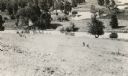
| Date: | 1900 |
|---|---|
| Description: | Elevated view of wagon bridge in Darlington, with a river on the right, a cow in a field, and a building on the left. |
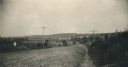
| Date: | 1935 |
|---|---|
| Description: | Elevated view of Darlington, with the bridge over the river in the foreground, and the town beyond. Caption reads: "View from the Hill, Darlington, Wis." |

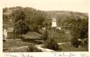
| Date: | 1910 |
|---|---|
| Description: | Elevated view of the Pecatonica River, which is curving from left to right, making two hairpin turns among fields and trees. Hills are in the distance. |
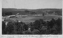
| Date: | |
|---|---|
| Description: | Elevated view from hill of the racetrack at the "Big White Fair". |

| Date: | 1874 |
|---|---|
| Description: | Map of New Diggings — inset map in bottom right corner of "Benton & New Diggings" map, on page 11 of "Atlas of Lafayette County Wisconsin," a collect... |
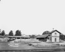
| Date: | |
|---|---|
| Description: | Elevated view across railroad tracks of a lumber yard. A two-story building on the right has a sign that says: "Lovejoy & Ringham". There are fences, a sto... |

| Date: | 1836 |
|---|---|
| Description: | A series of ink, watercolor, and pencil on paper, hand-drawn maps of the townships of Darlington and Gratiot in Lafayette County, Wisconsin, showing the to... |

| Date: | 1830 |
|---|---|
| Description: | An ink on paper, hand-drawn map, showing the wagons roads that travel through Lafayette County, traveling between Galena, Illinois, and Mineral Point, Wisc... |

| Date: | 1990 |
|---|---|
| Description: | A tourist map of Lafayette County, Wisconsin, that shows the locations of motels, camping, municipal parks, cheese factory tours, waysides, and golf course... |

| Date: | 02 28 1948 |
|---|---|
| Description: | View up hill of cars driving in the flooded street of the downtown area. The downtown had also flooded in 1923 and 1937. The Pecatonica River rose rapidly ... |

| Date: | 1932 |
|---|---|
| Description: | Esther Peterson, a student at Mud Branch School, District No. 2, poses leaning against a tree on a hill while holding a baseball bat. There is a road and f... |

| Date: | 1932 |
|---|---|
| Description: | Violet Jacobson, a student at Mud Branch School, District No. 2, poses on her family's farm with several calves. There is a barn and two other outbuildings... |

| Date: | 1932 |
|---|---|
| Description: | The Theodore Vinger farmstead sits on gently rolling terrain. A painted sign on the large barn identifies the owner. At the time of the photograph, Martin ... |

| Date: | 1932 |
|---|---|
| Description: | View up road towards two men posing near the front of a cheese factory on a small hill; on the right a woman and two girls stand near a side door. Typical ... |

| Date: | 1932 |
|---|---|
| Description: | Several old timbers are exposed on Mud Branch Road. A one-mile stretch of the road was originally constructed as a corduroy road because of "quick sand" in... |
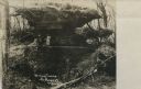
| Date: | |
|---|---|
| Description: | Photographic postcard view of a rock formation called "Dining Table" with two people posing next to it. Caption reads: "Dining Table, Belmont Mounds." |

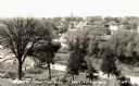
| Date: | 1910 |
|---|---|
| Description: | Aerial view along river toward Darlington. Caption reads: "Bird's-Eye View, Darlington, Wis." |

| Date: | 1857 |
|---|---|
| Description: | This map shows lot numbers, lot dimensions (in chains and links), and a mineral reservation for use of proprietors. Includes certifications signed in Sept.... |
If you didn't find the material you searched for, our Library Reference Staff can help.
Call our reference desk at 608-264-6535 or email us at: