 Filter: Categories of Wisconsin Historical Images
Filter: County of Lafayette
Filter: Subject of transportation
Filter: Categories of Wisconsin Historical Images
Filter: County of Lafayette
Filter: Subject of transportation

| Date: | 1932 |
|---|---|
| Description: | View up road towards two men posing near the front of a cheese factory on a small hill; on the right a woman and two girls stand near a side door. Typical ... |

| Date: | 1932 |
|---|---|
| Description: | Several old timbers are exposed on Mud Branch Road. A one-mile stretch of the road was originally constructed as a corduroy road because of "quick sand" in... |

| Date: | 1912 |
|---|---|
| Description: | Photographic postcard view of a central business district. On the left is a bank, and a "Place to Eat." Horses and buggies are further down the block. Capt... |

| Date: | |
|---|---|
| Description: | Elevated photographic postcard view of a busy road near Blanchardville. Men are driving a wagon hitched to eight horses, and people are standing in the roa... |

| Date: | 1836 |
|---|---|
| Description: | This map of Belmont includes notarization from the justice of the peace of Iowa County, May 15, 1836, acknowledging John Atchison as proprietor of Belmont ... |

| Date: | 1882 |
|---|---|
| Description: | Plat map of the village of Dunbarton, received by the Lafayette County Register's Office on September 22, 1892. Certification by the surveyor, Albert Pool,... |

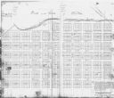
| Date: | 1855 |
|---|---|
| Description: | This map is ink, pen, and watercolor on paper and shows plat of the town, local streets, lots by number, U.S. subdivisions in red lines, Mineral Point Rail... |
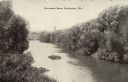
| Date: | 1910 |
|---|---|
| Description: | Elevated view looking up the Pecatonica River. Caption reads: "Pecatonica River, Darlington, Wis." |

| Date: | 1910 |
|---|---|
| Description: | Aerial view along river toward Darlington. Caption reads: "Bird's-Eye View, Darlington, Wis." |
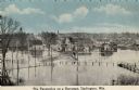
| Date: | 1910 |
|---|---|
| Description: | Elevated view of the Pecatonica River at the bridge. The river is flooding the town. Caption reads: "Pecatonica River on a Rampage, Darlington, , Wis." |
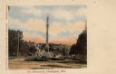
| Date: | 1910 |
|---|---|
| Description: | View down hill toward the Soldier's Monument. Caption reads: "The Monument, Darlington, Wis." |

| Date: | 1940 |
|---|---|
| Description: | Photographic postcard view from street intersection of the High School gymnasium. Caption reads: "High School Gymnasium, Darlington, Wis." |

| Date: | 1836 |
|---|---|
| Description: | This map is ink and watercolor on paper and shows a plat of a paper city (a city planned but never built). Some streets and the Pekatolica River are labele... |

| Date: | 08 07 2012 |
|---|---|
| Description: | A westerly view down Water Street, including Turpin's Grocery, a bar and several American flags. |

| Date: | 08 07 2012 |
|---|---|
| Description: | A view of a portion of the Methodist Episcopal Church. There is a car parked in front of the building. |
| Date: | |
|---|---|
| Description: | This photocopy of a map shows the paper city of Wiota on the East Pecatonica River in Lafayette County. After this village failed to prosper, some of its ... |

| Date: | 04 19 2012 |
|---|---|
| Description: | A view of the downtown area on a rainy day. The Woodford State Bank is on the left, and the street is lined with various storefronts and taverns. There is ... |

| Date: | 04 19 2012 |
|---|---|
| Description: | View towards the curve of Darlington Road when approaching Blanchardville. |

| Date: | 02 25 2012 |
|---|---|
| Description: | Exterior view of a Cenex filling station, which includes a food court and convenience store. There is a truck with a trailer passing the station in the for... |

| Date: | 06 21 2012 |
|---|---|
| Description: | View down the center of the street of downtown business district. |
If you didn't find the material you searched for, our Library Reference Staff can help.
Call our reference desk at 608-264-6535 or email us at: