Filter: Categories of Wisconsin Historical Images
Filter: County of Marathon
Filter: Subject of transportation
Filter: Categories of Wisconsin Historical Images
Filter: County of Marathon
Filter: Subject of transportation

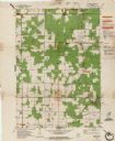
| Date: | 1987 |
|---|---|
| Description: | This pictorial map shows roads, bridges, local businesses with phone numbers, and public buildings. Relief is shown pictorially. Also included is a calen... |

| Date: | 1899 |
|---|---|
| Description: | This map is ink on tracing cloth and shows lot and block numbers and dimensions, streets, the high school park, and survey monuments. The map is oriented ... |
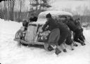
| Date: | 1938 |
|---|---|
| Description: | Scouts at a winter camp push a car stuck in deep snow. Trees are in the background. |
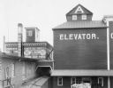
| Date: | 1898 |
|---|---|
| Description: | Slightly elevated view of the Cereal Mills Company. Men are working near a horse-drawn wagon near an entrance to a grain elevator in the lower right. Railr... |
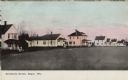
| Date: | 1908 |
|---|---|
| Description: | Colorized view of a row of wood frame houses. Caption reads: "Residence Street, Edgar, Wis." |

| Date: | |
|---|---|
| Description: | A young woman and a child are sitting on a toboggan. On the left is a black lab running towards them. |

| Date: | |
|---|---|
| Description: | A young woman is pulling a a boy laying in a toboggan across the snow. Trees are behind them. |
| Date: | 07 1936 |
|---|---|
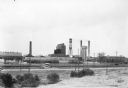
| Description: | View across field towards a bus sitting in the driveway in front of a large factory complex, which has a water tower and three smokestacks. "Airport 2 Mi."... |

| Date: | 1935 |
|---|---|
| Description: | Slightly elevated view of the Eau Claire River flowing between block-like rock formations downstream from a stone bridge in the Dells of the Eau Claire Cou... |

| Date: | 1901 |
|---|---|
| Description: | A plat map of Marathon county, 28 township, north range, 7 east. |

| Date: | 1901 |
|---|---|
| Description: | A plat map of Marathon county, township 28, north range, 8 east. |

| Date: | 1901 |
|---|---|
| Description: | A plat map of Marathon county, township 29, north range, 6 east. |

| Date: | 1901 |
|---|---|
| Description: | A plat map of Marathon county, township 29, north range, 7 east. |

| Date: | 1901 |
|---|---|
| Description: | A plat map of Marathon county, township 29, north range, 8 east. |
| Date: | 04 1962 |
|---|---|
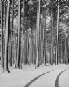
| Description: | Tire tracks in fresh snow at Marathon park. The road is lined with snow-covered pines. |
| Date: | 10 07 1908 |
|---|---|
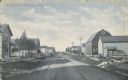
| Description: | Text on front reads: "Street Scene, Stratford, Wis." An unpaved street with boardwalks and dwellings on the left, more dwellings and farm buildings on the ... |

| Date: | 1911 |
|---|---|
| Description: | Text on front reads: "Rothchild's Park Pavilion, Wausau, Wis." The Prairie School style stone building was built in 1911. Street car tracks can be seen on ... |

| Date: | 1909 |
|---|---|
| Description: | Text on front reads: "The Post Office Building, Wausau, Wisconsin." Built of brick and stone, all of the windows have striped awnings and there is an ornat... |
If you didn't find the material you searched for, our Library Reference Staff can help.
Call our reference desk at 608-264-6535 or email us at: