 Filter: Categories of Wisconsin Historical Images
Filter: County of Marinette
Filter: Type of Photograph
Filter: Subject of outdoor photography
Filter: Categories of Wisconsin Historical Images
Filter: County of Marinette
Filter: Type of Photograph
Filter: Subject of outdoor photography
| Date: | |
|---|---|
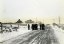
| Description: | Wisconsin Land Economic Inventory mapping crew starting out in the snow for instruction. |

| Date: | 1930 |
|---|---|
| Description: | The County Agricultural and Teacher Training School. |
| Date: | 1938 |
|---|---|
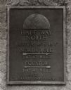
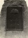
| Description: | The 45th parallel of north latitude marker, marking halfway between the equator and the north pole. The marker is located on Highway 141, three miles north... |
| Date: | 1900 |
|---|---|
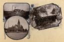
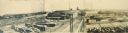
| Description: | Composite of views of Oakwood Beach Lodge, Pioneer Presbyterian Church and a sawmill. |
| Date: | 1905 |
|---|---|
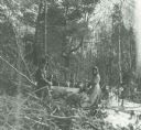
| Description: | Man and woman using a double-handled saw to clear trees from their land. |
| Date: | |
|---|---|
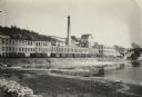
| Description: | The Menominee River and paper mill as photographed by William A. Hotchkiss for the Wisconsin Good Roads Association. |
| Date: | 1910 |
|---|---|
| Description: | An elevated view of town. A church is on the left, houses are in rows on the right. Caption reads: "Made-For-Club-House — Niagara-Wis.—". |
| Date: | 1940 |
|---|---|
| Description: | A view of a marker on highway 41 designating the half way point between the Equator and the North Pole. |

| Date: | 1900 |
|---|---|
| Description: | A view of the lighthouse and dock office at Peshtigo Harbor. |
| Date: | |
|---|---|
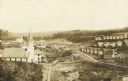
| Description: | Triptych panoramic view of Marinette lumber district, with M & M Box Company factory in the center. |
| Date: | 1918 |
|---|---|
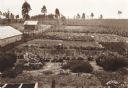
| Description: | Elevated view of two women working in a large vegetable garden. A long building, perhaps a barn, and a smaller building are on the left. In the background ... |

| Date: | |
|---|---|
| Description: | Two men with cows in the barnyard of farm. |
| Date: | 1930 |
|---|---|
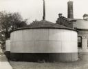
| Description: | Storage Tank #2. A large, rounded tank with a conical roof. Another tank is directly behind. A large brick building is on the right. |

| Date: | 1930 |
|---|---|
| Description: | West side of filter building. Pipes are stacked on the right side of the building, and part of a storage tank can be seen on the left. |

| Date: | 1930 |
|---|---|
| Description: | Front view of pump room, side of part of Boiler Room. |
| Date: | 1923 |
|---|---|
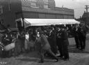
| Description: | A street gathering of people interested in using war-salvaged explosives for a land clearance program. |

| Date: | 2008 |
|---|---|
| Description: | Built in about 1933, this appealingly picturesque service station, located at 1305 Pierce Avenue, was designed to blend into the neighborhood. |

| Date: | |
|---|---|
| Description: | Exterior view from road of the Stephenson Public Library. Above the main entrance it reads: "Stephenson Public Library." The library is a cut stone buildin... |
| Date: | |
|---|---|
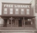
| Description: | Exterior view of the Wausaukee Public Library. Above the windows on the second floor is painted: "Free Library" in large letters. Two signs advertise: "Boo... |
If you didn't find the material you searched for, our Library Reference Staff can help.
Call our reference desk at 608-264-6535 or email us at:
