Filter: Categories of Wisconsin Historical Images
Filter: County of Monroe
Filter: Subject of cities and towns
Filter: Subject of water
Filter: Categories of Wisconsin Historical Images
Filter: County of Monroe
Filter: Subject of cities and towns
Filter: Subject of water

| Date: | 05 31 1965 |
|---|---|
| Description: | Elevated view of Evangelical United Brethren church in the vicinity of Highway T. |
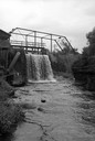
| Date: | 06 02 1943 |
|---|---|
| Description: | View from shoreline of bridge and stream. |
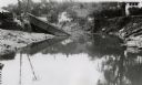
| Date: | 06 02 1943 |
|---|---|
| Description: | View from water of bridge collapsed into the river, with the metal supports half submerged and the brick base crumbling. Dwellings can be seen along the hi... |
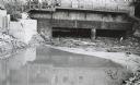
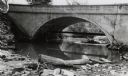
| Date: | 06 02 1943 |
|---|---|
| Description: | Behind the drugstore, looking downstream. The water under the bridge is full of construction debris. |

| Date: | 1912 |
|---|---|
| Description: | This map shows the area around Fort McCoy, labeled "U.S. Military Reservation," and Camp Douglas in the Sparta-Tomah region. Road, railroads, towns, cities... |
| Date: | 1922 |
|---|---|
| Description: | A map of the Beaver Creek Valley in Monroe, Wisconsin along Beaver Creek and the La Crosse River, showing roads, railroads, and land ownership as well as p... |

| Date: | 1877 |
|---|---|
| Description: | A map of Monroe County, Wisconsin that shows the townships and landownership and acreage wagon roads, railroads, streams, schools, and houses. Also include... |

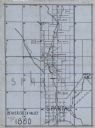
| Date: | 1912 |
|---|---|
| Description: | A map of Monroe County, Wisconsin showing townships, the towns of Sparta, Tomah, Oakdale, Wilton, Cashton, Glendale, Kendall and Wyeville, as well as the U... |

| Date: | 1940 |
|---|---|
| Description: | This maps shows the areas in Monroe, Jackson, and Juneau counties, Wisconsin, where U.S. Army maneuvers were held in August 1940. Highways and roads, commu... |

| Date: | 1903 |
|---|---|
| Description: | This map shows townships and sections, landownership and acreages, roads, railroads, and selected rural buildings. Townships and sections appear in yellow,... |

| Date: | 06 03 1911 |
|---|---|
| Description: | Text on front reads: "Maid of the Mist, Gillett Park, Tomah, Wis." A stone fountain with a statue of a woman in the center, holding a water vessel on her s... |

| Date: | 06 28 1917 |
|---|---|
| Description: | Text on front reads: "Spring Bank, Near Tomah." Three women and a man stand on a wooden suspension bridge over a pond on Sparta Creek. One woman is holding... |
If you didn't find the material you searched for, our Library Reference Staff can help.
Call our reference desk at 608-264-6535 or email us at: