 Filter: Categories of Wisconsin Historical Images
Filter: County of Oconto
Filter: Year of 1900-1999
Filter: Categories of Wisconsin Historical Images
Filter: County of Oconto
Filter: Year of 1900-1999
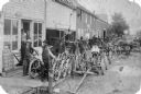
| Date: | 1900 |
|---|---|
| Description: | Large group of people posed in commercial area on a wooden sidewalk. Leigeois Bar, Implement Store, and Blacksmith Shop. Joseph Leigeois is shown in the fo... |

| Date: | 1900 |
|---|---|
| Description: | Men and boys posing with horses and horse-drawn vehicles in front of the Baudhuin and Svoboda store. There is a Post Office sign on the building. |
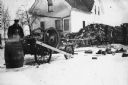
| Date: | 1900 |
|---|---|
| Description: | John Liegeois at Dutton Farm. John had an identical establishment in Little Suamico. Joeseph Jr. and John and Louis Liegeois and Rachel were born in (Robi... |
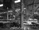
| Date: | 05 25 1963 |
|---|---|
| Description: | An interior view of Treasure City, a souvenir shop on a highway which travels north from Chicago, Illinois. Nets of sea shells, displays of jewelery, and m... |

| Date: | 02 13 1970 |
|---|---|
| Description: | Evening grosbeaks at a feeder seen through a window. |
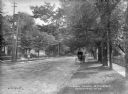
| Date: | 1905 |
|---|---|
| Description: | View along right side terrace, looking down tree-lined West Main Street. Houses are on the left side. Along the curb on the right a woman is standing besid... |
| Date: | 1969 |
|---|---|
| Description: | Building on the west side of Superior Street where Joseph Ruelle was shot. |
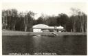
| Date: | 1945 |
|---|---|
| Description: | Photographic postcard of the Tip Top Dance Pavillion on Anderson Lake. The view from the lake shows several automobiles parked outside the pavillion. The s... |
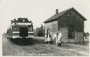
| Date: | 1943 |
|---|---|
| Description: | Photographic postcard of a train stopped at the Chicago & North West railroad station. A small group of people stand in the grass waiting beside the tracks... |
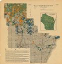
| Date: | 1920 |
|---|---|
| Description: | This map shows the township and range system, sections, cities and villages, railroads, roads, and streams and lakes in Oconto County, Wisconsin. Color co... |

| Date: | 1922 |
|---|---|
| Description: | This map from the early to mid-20th century shows the township and range system, towns, cities and villages, roads, railroads, schools, churches, cemeterie... |

| Date: | 1908 |
|---|---|
| Description: | This early 20th century map shows the township and range system, sections, state-owned land, selected buildings and landownership, railroads, bridges, and ... |

| Date: | 1922 |
|---|---|
| Description: | This map from the early to mid-20th century shows the township and range system, towns, cities and villages, roads, railroads, schools, churches, and lakes... |

| Date: | 1910 |
|---|---|
| Description: | Photographic postcard view of the Elkhorn Creamery building. |
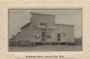
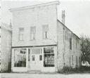
| Date: | 1910 |
|---|---|
| Description: | View of the Windross Store, Cream City. |

| Date: | 1935 |
|---|---|
| Description: | This map shows streets, railroads, and city wards. Streets, the Oconto River, and the Green Bay are labeled. The bottom of the map reads: "Compliments of O... |
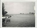
| Date: | 07 21 1960 |
|---|---|
| Description: | View from Oconto looking out into Green Bay Channel, which is often too shallow between the log pilings and lighthouse. Boats and docks are docked along th... |

| Date: | 12 17 1957 |
|---|---|
| Description: | View across icy water towards shipping boats in harbor. Trees are along the right shoreline, houses and buildings are along the left shoreline. |
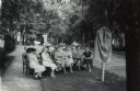
| Date: | 06 10 1955 |
|---|---|
| Description: | A small group is gathered for the dedication and unveiling of the First Church of Christ, Scientist historical marker in Oconto. Raymond Sivesind, supervis... |
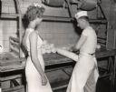
| Date: | 07 26 1960 |
|---|---|
| Description: | Alice in Dairyland, Joan Engh, watching as a man ties a provolone cheese. |
If you didn't find the material you searched for, our Library Reference Staff can help.
Call our reference desk at 608-264-6535 or email us at: