 Filter: Categories of Wisconsin Historical Images
Filter: County of Oneida
Filter: Year of 1900-1999
Filter: Subject of human settlements
Filter: Categories of Wisconsin Historical Images
Filter: County of Oneida
Filter: Year of 1900-1999
Filter: Subject of human settlements
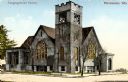
| Date: | 1913 |
|---|---|
| Description: | Exterior view of a congregational church. Caption reads: "Congregational Church, Rhinelander, Wis." |

| Date: | 1905 |
|---|---|
| Description: | Caption reads: Panoramic View of Minocqua, Wis." A railroad bridge is in the foreground. |

| Date: | 1916 |
|---|---|
| Description: | Elevated view of the town from a boxcar. People are posing in the street on the right. A lake is in the upper right, and railroad tracks and a rail car are... |

| Date: | 1916 |
|---|---|
| Description: | Elevated view of the town from a boxcar. A railroad train is headed towards a bridge over the lake. Caption reads: The ideal fishing resort of the One Thou... |
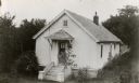
| Date: | 1930 |
|---|---|
| Description: | Church built by early settlers in the village of New Upsala, the first Swedish settlement in Wisconsin. |

| Date: | 09 27 1942 |
|---|---|
| Description: | Labeled as a "freak" snowstorm. A boathouse takes up the majority of the image, with a flag flying over the boathouse. The lake is not frozen, but ice and... |

| Date: | 1921 |
|---|---|
| Description: | A boy parades past the Oneida County courthouse with a sign that reads, "Others Quickly Followed." |
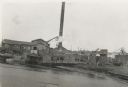
| Date: | 1939 |
|---|---|
| Description: | A view from water of the Thunder Lake Lumber Co., one of the largest sawmills in Rhinelander. It was located on Lake Creek and operated until 1937. |

| Date: | 1920 |
|---|---|
| Description: | This early 1920s map shows state-owned land in townships 38 and 39, range 7 east, the towns of Lake Tomahawk and Woodruff, in Oneida County, Wisconsin, tha... |
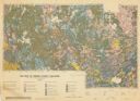
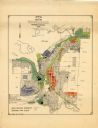
| Date: | 1959 |
|---|---|
| Description: | Map of soil in Oneida County. Bottom of the map includes a legend of soil; "SECOND CLASS SOILS GOOD TO FAIR FARM LAND" are represented in shades of yellow ... |
| Date: | 1956 |
|---|---|
| Description: | This map of Rhinelander shows lots, 6 types of zoning in various colors; heavy industry, light industry, commercial, residence "A," residence "unrated," lo... |
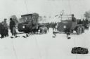
| Date: | 01 31 1926 |
|---|---|
| Description: | Winter scene of early snowmobile race at Rangeline Lake. Bill Neu (right), winner, Harold Hansen (left). Special conversion kits were available which allow... |

| Date: | 01 1969 |
|---|---|
| Description: | A map of Oneida county, which includes a small drawing of a hodag. |

| Date: | 1962 |
|---|---|
| Description: | This map shows roads, golf courses, ski areas, boat landings, camp sites, waysides, parks, beaches, scenic views, virgin timber tracts, airports, boys and ... |

| Date: | 1900 |
|---|---|
| Description: | Photographic postcard of the James G. Dunn Grocery, with William John Dunn standing on the left and Maggie (O'Hare) Dunn on the right. Handwritten on the... |

| Date: | 1940 |
|---|---|
| Description: | This map shows lakes, roads, car trails, foot trails, railroads, resorts and camps, and fire towers. The map includes an inset location map and pictorial d... |
| Date: | 1996 |
|---|---|
| Description: | This photocopy plat map shows "old" Pennington, a village situated in section 26 of township 37 north, range 10 east, alongside the Minneapolis, Sault Ste ... |

| Date: | 01 1968 |
|---|---|
| Description: | Groups of people are walking or standing downtown along the snow-covered street at night. Snowmobiles are parked in the right foreground. A banner stretchi... |

| Date: | 01 1968 |
|---|---|
| Description: | Elevated view of a crowd of people with snowmobiles standing on both sides of a snowy street downtown. There is a sign for a barbershop on the left, and a ... |

| Date: | 10 05 1948 |
|---|---|
| Description: | Aerial photograph of the Baumgartner Dairy Farm, one half mile east of Three Lakes, WI. |
If you didn't find the material you searched for, our Library Reference Staff can help.
Call our reference desk at 608-264-6535 or email us at: