 Filter: Categories of Wisconsin Historical Images
Filter: County of Oneida
Filter: Year of 1900-1999
Filter: Subject of transportation
Filter: Categories of Wisconsin Historical Images
Filter: County of Oneida
Filter: Year of 1900-1999
Filter: Subject of transportation

| Date: | 09 27 1942 |
|---|---|
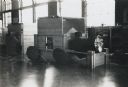
| Description: | Labeled as a "freak" snowstorm. A boathouse takes up the majority of the image, with a flag flying over the boathouse. The lake is not frozen, but ice and... |

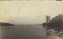
| Date: | 1907 |
|---|---|
| Description: | View from water of the Chicago Milwaukee and St. Paul railroad bridge. Probably over a stretch of Kawaguasaga Lake. There is a stairway leading to the wate... |
| Date: | 1939 |
|---|---|
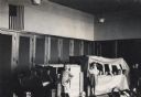
| Description: | A group of students playing in their kindergarten classroom with a large train model. |
| Date: | 1939 |
|---|---|
| Description: | A large model of a train for students to play with in a kindergarten classroom. |

| Date: | 1983 |
|---|---|
| Description: | Harvested cranberries being unloaded from a truck for cleaning and processing. A woman stands over the cranberries with a rake while adjusting the flow of ... |

| Date: | 1915 |
|---|---|
| Description: | This 1915 map shows railroads, wagon roads, trails, creeks, rivers, lakes, and trout streams in Oneida and Lincoln counties within a 12 mile radius of Rhin... |
| Date: | 1959 |
|---|---|
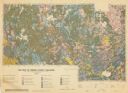
| Description: | Map of soil in Oneida County. Bottom of the map includes a legend of soil; "SECOND CLASS SOILS GOOD TO FAIR FARM LAND" are represented in shades of yellow ... |
| Date: | 01 23 1957 |
|---|---|
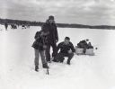
| Description: | Lee Jameson, Walter Jameson, and Jim Stern clearing an ice fishing hole in Thunder Lake. |

| Date: | 1900 |
|---|---|
| Description: | This map of Three Lakes shows forest fire lookout towers, picnic grounds, an airport, roads, and railroad. The map features text boxes on the Village of Th... |
| Date: | 1956 |
|---|---|
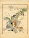
| Description: | This map of Rhinelander shows lots, 6 types of zoning in various colors; heavy industry, light industry, commercial, residence "A," residence "unrated," lo... |
| Date: | 08 05 1916 |
|---|---|
| Description: | View across water of The Narrows in Trout Lake. There are people in a canoe out on the lake. Caption reads: "'The Narrows' Trout Lake, Wood Cliff, Wis." |
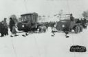
| Date: | 01 31 1926 |
|---|---|
| Description: | Winter scene of early snowmobile race at Rangeline Lake. Bill Neu (right), winner, Harold Hansen (left). Special conversion kits were available which allow... |

| Date: | 01 1969 |
|---|---|
| Description: | A map of Oneida county, which includes a small drawing of a hodag. |

| Date: | 1962 |
|---|---|
| Description: | This map shows roads, golf courses, ski areas, boat landings, camp sites, waysides, parks, beaches, scenic views, virgin timber tracts, airports, boys and ... |

| Date: | 1900 |
|---|---|
| Description: | Photographic postcard of the James G. Dunn Grocery, with William John Dunn standing on the left and Maggie (O'Hare) Dunn on the right. Handwritten on the... |

| Date: | 1900 |
|---|---|
| Description: | This map shows logging roads, railroads with spur lines, trails, rapids, lumber camps, Indian villages, summer resort, lakes, rivers, and ponds. |

| Date: | 1940 |
|---|---|
| Description: | This map shows lakes, roads, car trails, foot trails, railroads, resorts and camps, and fire towers. The map includes an inset location map and pictorial d... |
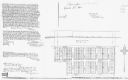
| Date: | 1996 |
|---|---|
| Description: | This photocopy plat map shows "old" Pennington, a village situated in section 26 of township 37 north, range 10 east, alongside the Minneapolis, Sault Ste ... |

| Date: | 1909 |
|---|---|
| Description: | View up a dirt path leading through a pine forest. Caption reads: "Northern Wisconsin Pine Forest, Near Hazelhurst, Wis." |
| Date: | 1963 |
|---|---|
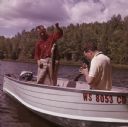
| Description: | A man is standing in a boat on Pine Lake, holding up a muskellunge he has caught. Another man is sitting in the boat holding a camera to take a photograph ... |
If you didn't find the material you searched for, our Library Reference Staff can help.
Call our reference desk at 608-264-6535 or email us at: