 Filter: Categories of Wisconsin Historical Images
Filter: County of Oneida
Filter: Year of 1900-1999
Filter: Year of 1950-1959
Filter: Type of Map or Atlas
Filter: Categories of Wisconsin Historical Images
Filter: County of Oneida
Filter: Year of 1900-1999
Filter: Year of 1950-1959
Filter: Type of Map or Atlas
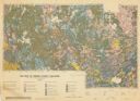
| Date: | 1959 |
|---|---|
| Description: | Map of soil in Oneida County. Bottom of the map includes a legend of soil; "SECOND CLASS SOILS GOOD TO FAIR FARM LAND" are represented in shades of yellow ... |
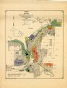
| Date: | 1956 |
|---|---|
| Description: | This map of Rhinelander shows lots, 6 types of zoning in various colors; heavy industry, light industry, commercial, residence "A," residence "unrated," lo... |
If you didn't find the material you searched for, our Library Reference Staff can help.
Call our reference desk at 608-264-6535 or email us at: